You are here: Home > Network List > TA - USArray Transportable Network (new EarthScope stations) Stations List
> Station V35K Ketchikan, AK, USA > Earthquake Result Viewer
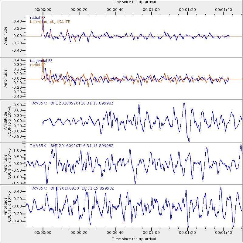
V35K Ketchikan, AK, USA - Earthquake Result Viewer
*The percent match for this event was below the threshold and hence no stack was calculated.
| Earthquake location: |
Southeast Of Honshu, Japan |
| Earthquake latitude/longitude: |
30.5/142.1 |
| Earthquake time(UTC): |
2016/09/20 (264) 16:21:16 GMT |
| Earthquake Depth: |
10 km |
| Earthquake Magnitude: |
6.1 MWW, 6.0 MWB |
| Earthquake Catalog/Contributor: |
NEIC PDE/NEIC COMCAT |
|
| Network: |
TA USArray Transportable Network (new EarthScope stations) |
| Station: |
V35K Ketchikan, AK, USA |
| Lat/Lon: |
55.33 N/131.62 W |
| Elevation: |
64 m |
|
| Distance: |
63.5 deg |
| Az: |
39.597 deg |
| Baz: |
285.779 deg |
| Ray Param: |
$rayparam |
*The percent match for this event was below the threshold and hence was not used in the summary stack. |
|
| Radial Match: |
52.265247 % |
| Radial Bump: |
310 |
| Transverse Match: |
66.05461 % |
| Transverse Bump: |
400 |
| SOD ConfigId: |
11737051 |
| Insert Time: |
2019-04-25 13:53:19.279 +0000 |
| GWidth: |
2.5 |
| Max Bumps: |
400 |
| Tol: |
0.001 |
|
Signal To Noise
| Channel | StoN | STA | LTA |
| TA:V35K: :BHZ:20160920T16:31:15.89998Z | 2.7618032 | 6.1768736E-7 | 2.2365367E-7 |
| TA:V35K: :BHN:20160920T16:31:15.89998Z | 0.76004386 | 1.377407E-7 | 1.812273E-7 |
| TA:V35K: :BHE:20160920T16:31:15.89998Z | 2.620671 | 3.151083E-7 | 1.2023955E-7 |
| Arrivals |
| Ps | |
| PpPs | |
| PsPs/PpSs | |


