You are here: Home > Network List > UW - Pacific Northwest Regional Seismic Network Stations List
> Station LEBA Lebam, WA, USA > Earthquake Result Viewer
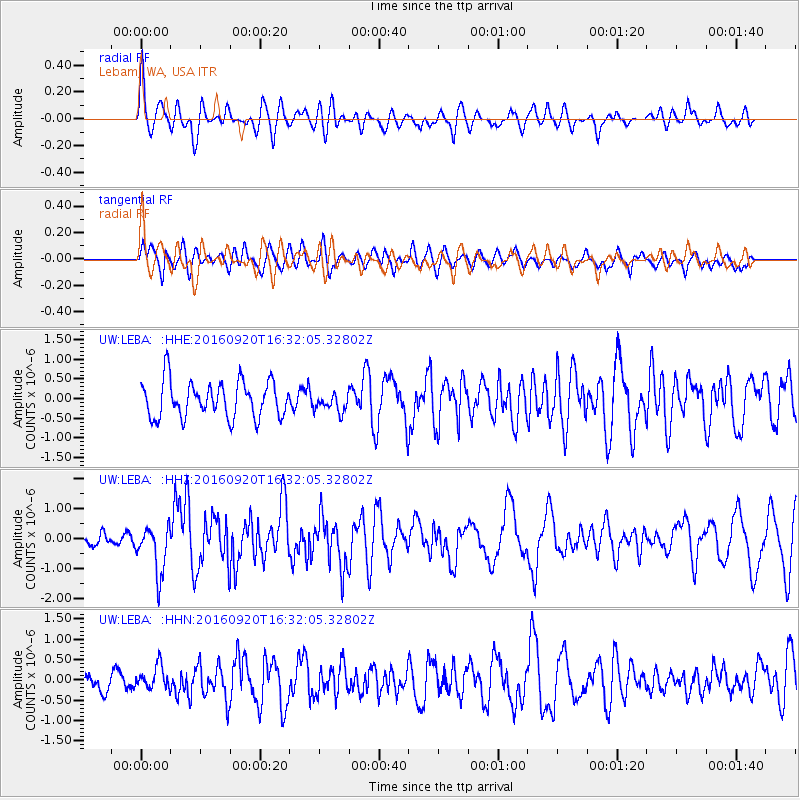
LEBA Lebam, WA, USA - Earthquake Result Viewer
*The percent match for this event was below the threshold and hence no stack was calculated.
| Earthquake location: |
Southeast Of Honshu, Japan |
| Earthquake latitude/longitude: |
30.5/142.1 |
| Earthquake time(UTC): |
2016/09/20 (264) 16:21:16 GMT |
| Earthquake Depth: |
10 km |
| Earthquake Magnitude: |
6.1 MWW, 6.0 MWB |
| Earthquake Catalog/Contributor: |
NEIC PDE/NEIC COMCAT |
|
| Network: |
UW Pacific Northwest Regional Seismic Network |
| Station: |
LEBA Lebam, WA, USA |
| Lat/Lon: |
46.55 N/123.56 W |
| Elevation: |
73 m |
|
| Distance: |
71.3 deg |
| Az: |
46.599 deg |
| Baz: |
294.738 deg |
| Ray Param: |
$rayparam |
*The percent match for this event was below the threshold and hence was not used in the summary stack. |
|
| Radial Match: |
56.07419 % |
| Radial Bump: |
400 |
| Transverse Match: |
61.002098 % |
| Transverse Bump: |
400 |
| SOD ConfigId: |
11737051 |
| Insert Time: |
2019-04-25 13:53:59.399 +0000 |
| GWidth: |
2.5 |
| Max Bumps: |
400 |
| Tol: |
0.001 |
|
Signal To Noise
| Channel | StoN | STA | LTA |
| UW:LEBA: :HHZ:20160920T16:32:05.32802Z | 2.0777347 | 8.046748E-7 | 3.8728467E-7 |
| UW:LEBA: :HHN:20160920T16:32:05.32802Z | 0.73302907 | 2.872527E-7 | 3.9187083E-7 |
| UW:LEBA: :HHE:20160920T16:32:05.32802Z | 0.4950371 | 2.2854354E-7 | 4.6166952E-7 |
| Arrivals |
| Ps | |
| PpPs | |
| PsPs/PpSs | |


