You are here: Home > Network List > UW - Pacific Northwest Regional Seismic Network Stations List
> Station PASS Maple Falls, WA, USA > Earthquake Result Viewer
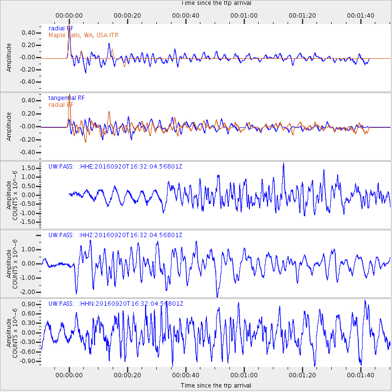
PASS Maple Falls, WA, USA - Earthquake Result Viewer
*The percent match for this event was below the threshold and hence no stack was calculated.
| Earthquake location: |
Southeast Of Honshu, Japan |
| Earthquake latitude/longitude: |
30.5/142.1 |
| Earthquake time(UTC): |
2016/09/20 (264) 16:21:16 GMT |
| Earthquake Depth: |
10 km |
| Earthquake Magnitude: |
6.1 MWW, 6.0 MWB |
| Earthquake Catalog/Contributor: |
NEIC PDE/NEIC COMCAT |
|
| Network: |
UW Pacific Northwest Regional Seismic Network |
| Station: |
PASS Maple Falls, WA, USA |
| Lat/Lon: |
49.00 N/122.09 W |
| Elevation: |
174 m |
|
| Distance: |
71.2 deg |
| Az: |
43.805 deg |
| Baz: |
294.931 deg |
| Ray Param: |
$rayparam |
*The percent match for this event was below the threshold and hence was not used in the summary stack. |
|
| Radial Match: |
79.84009 % |
| Radial Bump: |
400 |
| Transverse Match: |
59.13574 % |
| Transverse Bump: |
400 |
| SOD ConfigId: |
11737051 |
| Insert Time: |
2019-04-25 13:54:03.199 +0000 |
| GWidth: |
2.5 |
| Max Bumps: |
400 |
| Tol: |
0.001 |
|
Signal To Noise
| Channel | StoN | STA | LTA |
| UW:PASS: :HHZ:20160920T16:32:04.56801Z | 2.982511 | 7.882276E-7 | 2.6428324E-7 |
| UW:PASS: :HHN:20160920T16:32:04.56801Z | 0.9512288 | 2.5307455E-7 | 2.6605014E-7 |
| UW:PASS: :HHE:20160920T16:32:04.56801Z | 1.912249 | 4.7161765E-7 | 2.4662984E-7 |
| Arrivals |
| Ps | |
| PpPs | |
| PsPs/PpSs | |


