You are here: Home > Network List > YX16 - Raton Basin UNM Broadband Network Stations List
> Station UNM5 Southernmost CO Station > Earthquake Result Viewer
UNM5 Southernmost CO Station - Earthquake Result Viewer
| Earthquake location: |
Southeast Of Honshu, Japan |
| Earthquake latitude/longitude: |
30.5/142.1 |
| Earthquake time(UTC): |
2016/09/20 (264) 16:21:16 GMT |
| Earthquake Depth: |
10 km |
| Earthquake Magnitude: |
6.1 MWW, 6.0 MWB |
| Earthquake Catalog/Contributor: |
NEIC PDE/NEIC COMCAT |
|
| Network: |
YX Raton Basin UNM Broadband Network |
| Station: |
UNM5 Southernmost CO Station |
| Lat/Lon: |
37.12 N/104.78 W |
| Elevation: |
2035 m |
|
| Distance: |
88.1 deg |
| Az: |
47.341 deg |
| Baz: |
307.457 deg |
| Ray Param: |
0.04282403 |
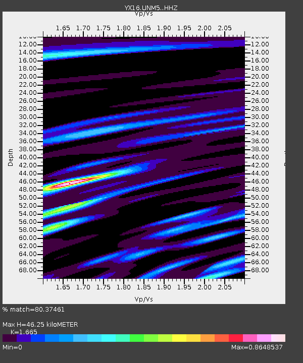
| Estimated Moho Depth: |
46.25 km |
| Estimated Crust Vp/Vs: |
1.66 |
| Assumed Crust Vp: |
6.316 km/s |
| Estimated Crust Vs: |
3.793 km/s |
| Estimated Crust Poisson's Ratio: |
0.22 |
|
| Radial Match: |
80.37461 % |
| Radial Bump: |
398 |
| Transverse Match: |
62.54912 % |
| Transverse Bump: |
400 |
| SOD ConfigId: |
11737051 |
| Insert Time: |
2019-04-25 13:55:27.216 +0000 |
| GWidth: |
2.5 |
| Max Bumps: |
400 |
| Tol: |
0.001 |
|

Signal To Noise
| Channel | StoN | STA | LTA |
| YX:UNM5: :HHZ:20160920T16:33:36.139971Z | 4.4391556 | 4.9016637E-7 | 1.1041883E-7 |
| YX:UNM5: :HHN:20160920T16:33:36.139971Z | 2.012809 | 1.4730169E-7 | 7.318215E-8 |
| YX:UNM5: :HHE:20160920T16:33:36.139971Z | 1.4398488 | 1.270303E-7 | 8.822475E-8 |
| Arrivals |
| Ps | 5.0 SECOND |
| PpPs | 19 SECOND |
| PsPs/PpSs | 24 SECOND |


