You are here: Home > Network List > US - United States National Seismic Network Stations List
> Station LSCT Lakeside, Connecticut, USA > Earthquake Result Viewer
LSCT Lakeside, Connecticut, USA - Earthquake Result Viewer
| Earthquake location: |
Near Coast Of Central Chile |
| Earthquake latitude/longitude: |
-30.8/-71.2 |
| Earthquake time(UTC): |
2004/12/08 (343) 06:03:55 GMT |
| Earthquake Depth: |
44 km |
| Earthquake Magnitude: |
5.7 MB, 5.0 MS, 5.8 MW, 5.7 MW |
| Earthquake Catalog/Contributor: |
WHDF/NEIC |
|
| Network: |
US United States National Seismic Network |
| Station: |
LSCT Lakeside, Connecticut, USA |
| Lat/Lon: |
41.68 N/73.22 W |
| Elevation: |
318 m |
|
| Distance: |
72.2 deg |
| Az: |
358.425 deg |
| Baz: |
178.192 deg |
| Ray Param: |
0.05375102 |
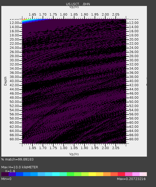
| Estimated Moho Depth: |
10.0 km |
| Estimated Crust Vp/Vs: |
1.60 |
| Assumed Crust Vp: |
6.472 km/s |
| Estimated Crust Vs: |
4.045 km/s |
| Estimated Crust Poisson's Ratio: |
0.18 |
|
| Radial Match: |
99.89183 % |
| Radial Bump: |
11 |
| Transverse Match: |
99.8777 % |
| Transverse Bump: |
15 |
| SOD ConfigId: |
110165 |
| Insert Time: |
2010-03-05 07:08:35.364 +0000 |
| GWidth: |
2.5 |
| Max Bumps: |
400 |
| Tol: |
0.001 |
|
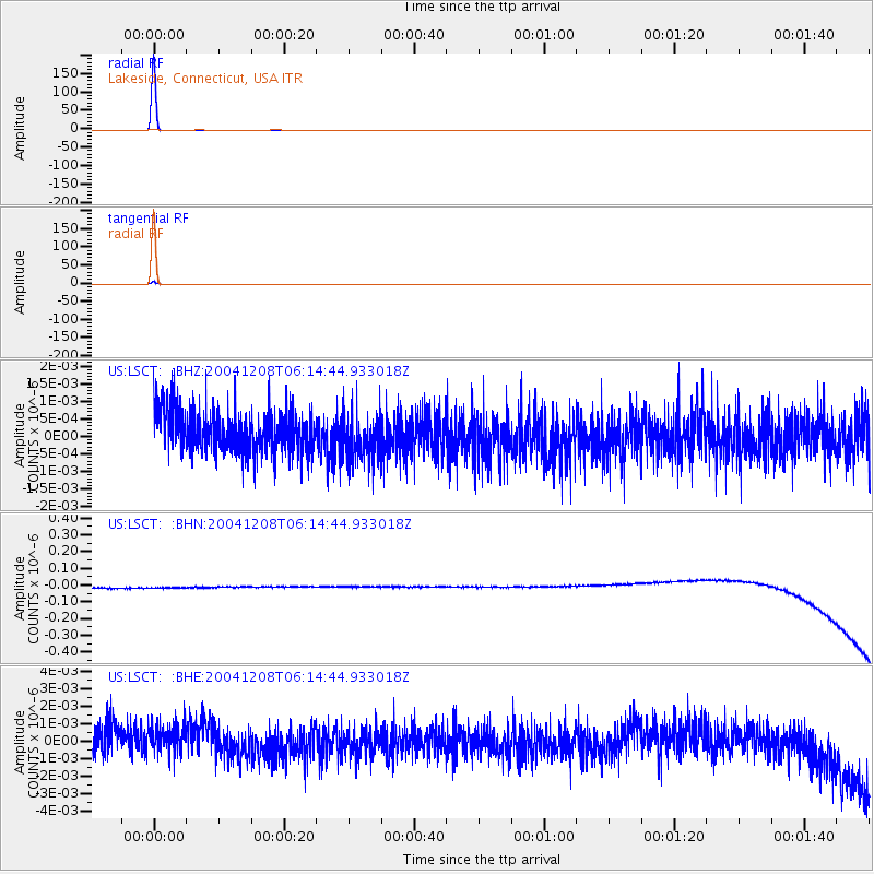
Signal To Noise
| Channel | StoN | STA | LTA |
| US:LSCT: :BHN:20041208T06:14:44.933018Z | 0.90959054 | 3.3334405E-8 | 3.6647705E-8 |
| US:LSCT: :BHE:20041208T06:14:44.933018Z | 0.8961511 | 7.916243E-10 | 8.8336033E-10 |
| US:LSCT: :BHZ:20041208T06:14:44.933018Z | 1.1494896 | 6.8535355E-10 | 5.962242E-10 |
| Arrivals |
| Ps | 1.0 SECOND |
| PpPs | 3.9 SECOND |
| PsPs/PpSs | 4.8 SECOND |


