You are here: Home > Network List > US - United States National Seismic Network Stations List
> Station LSCT Lakeside, Connecticut, USA > Earthquake Result Viewer
LSCT Lakeside, Connecticut, USA - Earthquake Result Viewer

| Earthquake location: |
Trinidad |
| Earthquake latitude/longitude: |
10.5/-61.5 |
| Earthquake time(UTC): |
2004/12/02 (337) 19:16:34 GMT |
| Earthquake Depth: |
49 km |
| Earthquake Magnitude: |
5.4 MB, 5.3 MS, 5.8 MW, 5.6 MW |
| Earthquake Catalog/Contributor: |
WHDF/NEIC |
|
| Network: |
US United States National Seismic Network |
| Station: |
LSCT Lakeside, Connecticut, USA |
| Lat/Lon: |
41.68 N/73.22 W |
| Elevation: |
318 m |
|
| Distance: |
32.7 deg |
| Az: |
343.624 deg |
| Baz: |
158.274 deg |
| Ray Param: |
0.07842388 |
| Estimated Moho Depth: |
10.0 km |
| Estimated Crust Vp/Vs: |
1.60 |
| Assumed Crust Vp: |
6.472 km/s |
| Estimated Crust Vs: |
4.045 km/s |
| Estimated Crust Poisson's Ratio: |
0.18 |
|
| Radial Match: |
99.86131 % |
| Radial Bump: |
16 |
| Transverse Match: |
99.844734 % |
| Transverse Bump: |
17 |
| SOD ConfigId: |
110165 |
| Insert Time: |
2010-03-05 07:08:37.084 +0000 |
| GWidth: |
2.5 |
| Max Bumps: |
400 |
| Tol: |
0.001 |
|
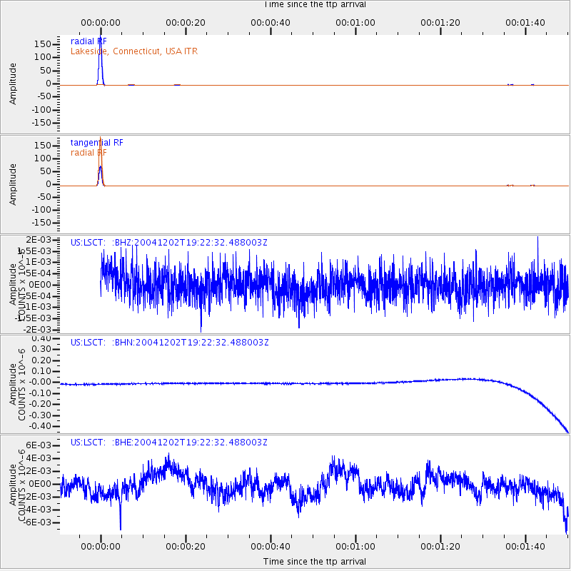
Signal To Noise
| Channel | StoN | STA | LTA |
| US:LSCT: :BHN:20041202T19:22:32.488003Z | 0.90520644 | 3.3350542E-8 | 3.6843023E-8 |
| US:LSCT: :BHE:20041202T19:22:32.488003Z | 1.7856928 | 2.1409063E-9 | 1.198922E-9 |
| US:LSCT: :BHZ:20041202T19:22:32.488003Z | 0.87658334 | 5.3852167E-10 | 6.143417E-10 |
| Arrivals |
| Ps | 1.0 SECOND |
| PpPs | 3.7 SECOND |
| PsPs/PpSs | 4.7 SECOND |


