You are here: Home > Network List > US - United States National Seismic Network Stations List
> Station LSCT Lakeside, Connecticut, USA > Earthquake Result Viewer
LSCT Lakeside, Connecticut, USA - Earthquake Result Viewer
| Earthquake location: |
Easter Island Region |
| Earthquake latitude/longitude: |
-26.5/-113.8 |
| Earthquake time(UTC): |
2004/11/28 (333) 02:35:13 GMT |
| Earthquake Depth: |
10 km |
| Earthquake Magnitude: |
5.6 MB, 6.1 MS, 6.6 MW, 6.5 MW |
| Earthquake Catalog/Contributor: |
WHDF/NEIC |
|
| Network: |
US United States National Seismic Network |
| Station: |
LSCT Lakeside, Connecticut, USA |
| Lat/Lon: |
41.68 N/73.22 W |
| Elevation: |
318 m |
|
| Distance: |
77.6 deg |
| Az: |
29.953 deg |
| Baz: |
216.667 deg |
| Ray Param: |
0.05023298 |
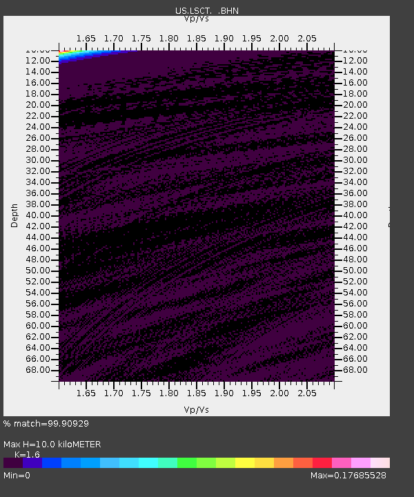
| Estimated Moho Depth: |
10.0 km |
| Estimated Crust Vp/Vs: |
1.60 |
| Assumed Crust Vp: |
6.472 km/s |
| Estimated Crust Vs: |
4.045 km/s |
| Estimated Crust Poisson's Ratio: |
0.18 |
|
| Radial Match: |
99.90929 % |
| Radial Bump: |
15 |
| Transverse Match: |
99.91024 % |
| Transverse Bump: |
15 |
| SOD ConfigId: |
110165 |
| Insert Time: |
2010-03-05 07:08:39.256 +0000 |
| GWidth: |
2.5 |
| Max Bumps: |
400 |
| Tol: |
0.001 |
|
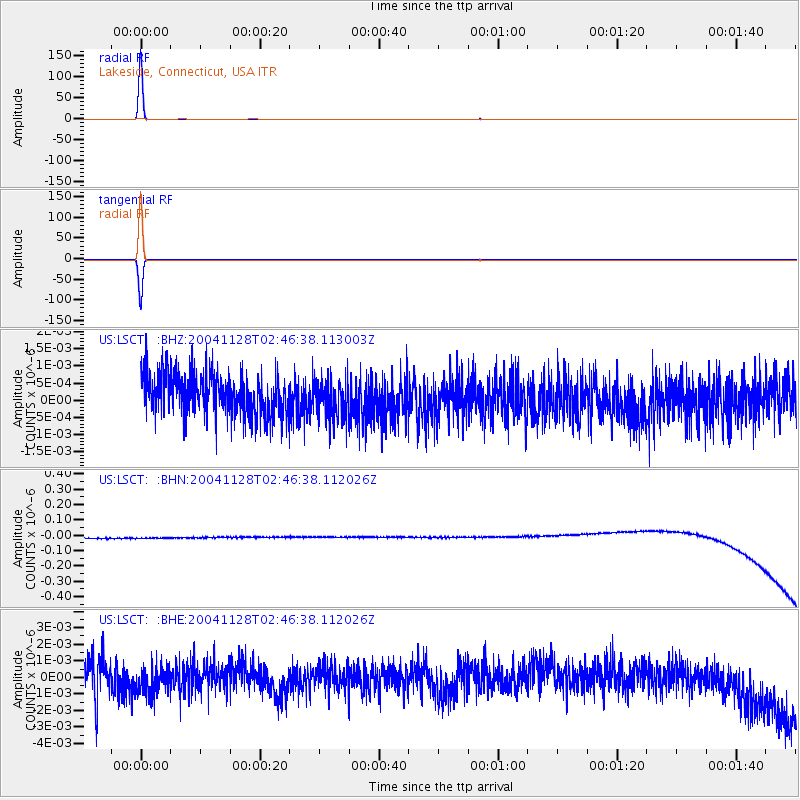
Signal To Noise
| Channel | StoN | STA | LTA |
| US:LSCT: :BHN:20041128T02:46:38.112026Z | 0.9173087 | 3.3502452E-8 | 3.652255E-8 |
| US:LSCT: :BHE:20041128T02:46:38.112026Z | 0.925575 | 8.8116364E-10 | 9.520175E-10 |
| US:LSCT: :BHZ:20041128T02:46:38.113003Z | 0.94786227 | 5.534754E-10 | 5.839196E-10 |
| Arrivals |
| Ps | 1.0 SECOND |
| PpPs | 3.9 SECOND |
| PsPs/PpSs | 4.8 SECOND |


