You are here: Home > Network List > US - United States National Seismic Network Stations List
> Station LSCT Lakeside, Connecticut, USA > Earthquake Result Viewer
LSCT Lakeside, Connecticut, USA - Earthquake Result Viewer
| Earthquake location: |
Costa Rica |
| Earthquake latitude/longitude: |
9.6/-84.2 |
| Earthquake time(UTC): |
2004/11/20 (325) 08:07:22 GMT |
| Earthquake Depth: |
16 km |
| Earthquake Magnitude: |
6.2 MB, 6.3 MS, 6.4 MW, 6.4 MW |
| Earthquake Catalog/Contributor: |
WHDF/NEIC |
|
| Network: |
US United States National Seismic Network |
| Station: |
LSCT Lakeside, Connecticut, USA |
| Lat/Lon: |
41.68 N/73.22 W |
| Elevation: |
318 m |
|
| Distance: |
33.4 deg |
| Az: |
14.987 deg |
| Baz: |
199.904 deg |
| Ray Param: |
0.07822349 |
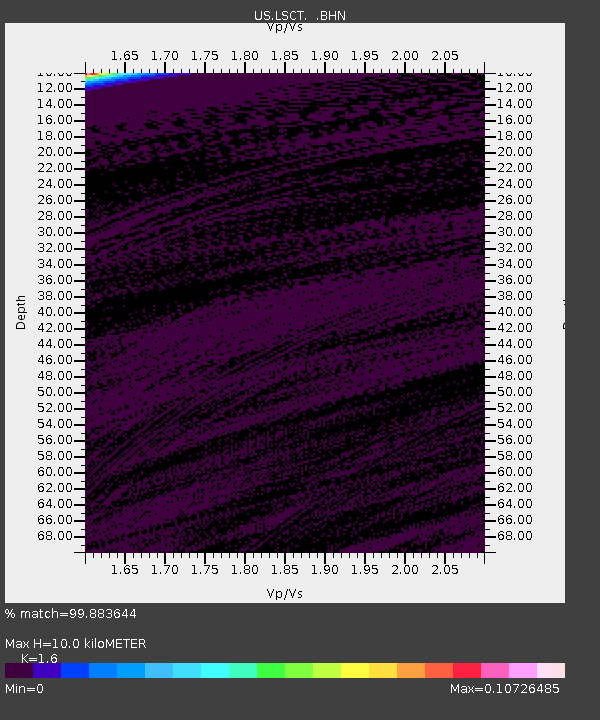
| Estimated Moho Depth: |
10.0 km |
| Estimated Crust Vp/Vs: |
1.60 |
| Assumed Crust Vp: |
6.472 km/s |
| Estimated Crust Vs: |
4.045 km/s |
| Estimated Crust Poisson's Ratio: |
0.18 |
|
| Radial Match: |
99.883644 % |
| Radial Bump: |
17 |
| Transverse Match: |
99.88457 % |
| Transverse Bump: |
17 |
| SOD ConfigId: |
110165 |
| Insert Time: |
2010-03-05 07:08:43.215 +0000 |
| GWidth: |
2.5 |
| Max Bumps: |
400 |
| Tol: |
0.001 |
|
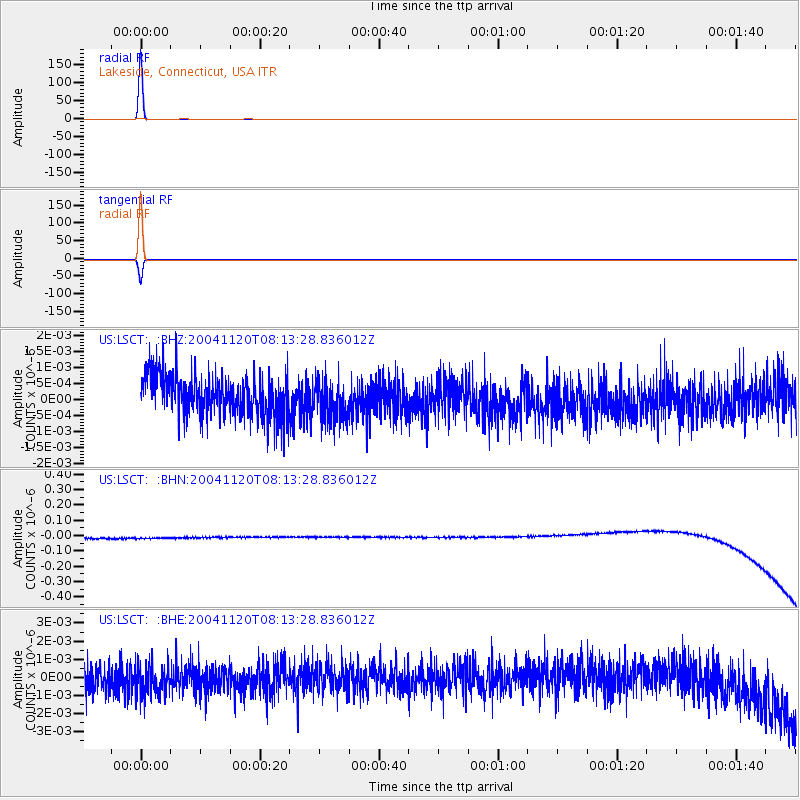
Signal To Noise
| Channel | StoN | STA | LTA |
| US:LSCT: :BHN:20041120T08:13:28.836012Z | 0.9182933 | 3.362019E-8 | 3.6611603E-8 |
| US:LSCT: :BHE:20041120T08:13:28.836012Z | 1.1694268 | 8.6261787E-10 | 7.376416E-10 |
| US:LSCT: :BHZ:20041120T08:13:28.836012Z | 1.0329823 | 6.2743777E-10 | 6.074042E-10 |
| Arrivals |
| Ps | 1.0 SECOND |
| PpPs | 3.7 SECOND |
| PsPs/PpSs | 4.7 SECOND |


