You are here: Home > Network List > US - United States National Seismic Network Stations List
> Station LSCT Lakeside, Connecticut, USA > Earthquake Result Viewer
LSCT Lakeside, Connecticut, USA - Earthquake Result Viewer
| Earthquake location: |
Near West Coast Of Colombia |
| Earthquake latitude/longitude: |
4.7/-77.5 |
| Earthquake time(UTC): |
2004/11/15 (320) 09:06:56 GMT |
| Earthquake Depth: |
15 km |
| Earthquake Magnitude: |
6.6 MB, 7.1 MS, 7.2 MW, 7.1 MW |
| Earthquake Catalog/Contributor: |
WHDF/NEIC |
|
| Network: |
US United States National Seismic Network |
| Station: |
LSCT Lakeside, Connecticut, USA |
| Lat/Lon: |
41.68 N/73.22 W |
| Elevation: |
318 m |
|
| Distance: |
37.0 deg |
| Az: |
5.332 deg |
| Baz: |
187.102 deg |
| Ray Param: |
0.07635005 |
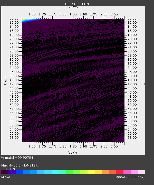
| Estimated Moho Depth: |
10.0 km |
| Estimated Crust Vp/Vs: |
1.60 |
| Assumed Crust Vp: |
6.472 km/s |
| Estimated Crust Vs: |
4.045 km/s |
| Estimated Crust Poisson's Ratio: |
0.18 |
|
| Radial Match: |
99.90784 % |
| Radial Bump: |
13 |
| Transverse Match: |
99.907684 % |
| Transverse Bump: |
13 |
| SOD ConfigId: |
110165 |
| Insert Time: |
2010-03-05 07:08:44.668 +0000 |
| GWidth: |
2.5 |
| Max Bumps: |
400 |
| Tol: |
0.001 |
|
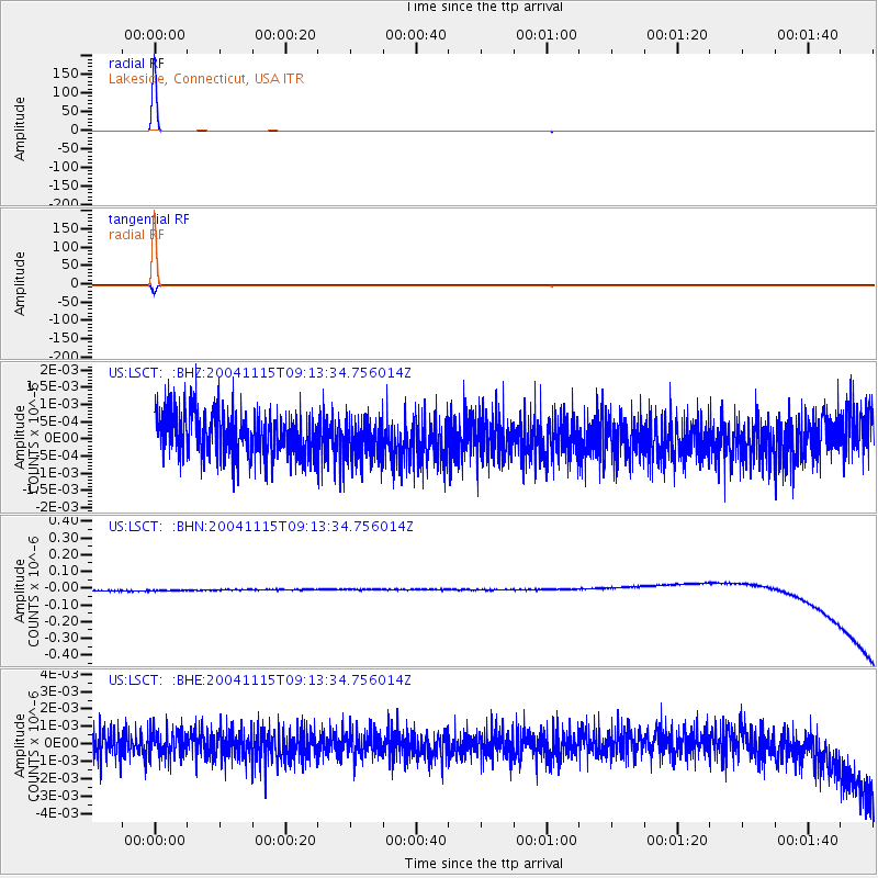
Signal To Noise
| Channel | StoN | STA | LTA |
| US:LSCT: :BHN:20041115T09:13:34.756014Z | 0.9134869 | 3.3241935E-8 | 3.6390162E-8 |
| US:LSCT: :BHE:20041115T09:13:34.756014Z | 0.8825352 | 7.1305817E-10 | 8.079657E-10 |
| US:LSCT: :BHZ:20041115T09:13:34.756014Z | 0.9363588 | 5.8286204E-10 | 6.2247724E-10 |
| Arrivals |
| Ps | 1.0 SECOND |
| PpPs | 3.7 SECOND |
| PsPs/PpSs | 4.7 SECOND |


