You are here: Home > Network List > US - United States National Seismic Network Stations List
> Station LSCT Lakeside, Connecticut, USA > Earthquake Result Viewer
LSCT Lakeside, Connecticut, USA - Earthquake Result Viewer
| Earthquake location: |
Near Coast Of Central Chile |
| Earthquake latitude/longitude: |
-37.7/-73.4 |
| Earthquake time(UTC): |
2004/05/03 (124) 04:36:50 GMT |
| Earthquake Depth: |
21 km |
| Earthquake Magnitude: |
5.9 MB, 6.5 MS, 6.6 MW, 6.6 MW |
| Earthquake Catalog/Contributor: |
WHDF/NEIC |
|
| Network: |
US United States National Seismic Network |
| Station: |
LSCT Lakeside, Connecticut, USA |
| Lat/Lon: |
41.68 N/73.22 W |
| Elevation: |
318 m |
|
| Distance: |
79.0 deg |
| Az: |
0.139 deg |
| Baz: |
180.147 deg |
| Ray Param: |
0.04924292 |
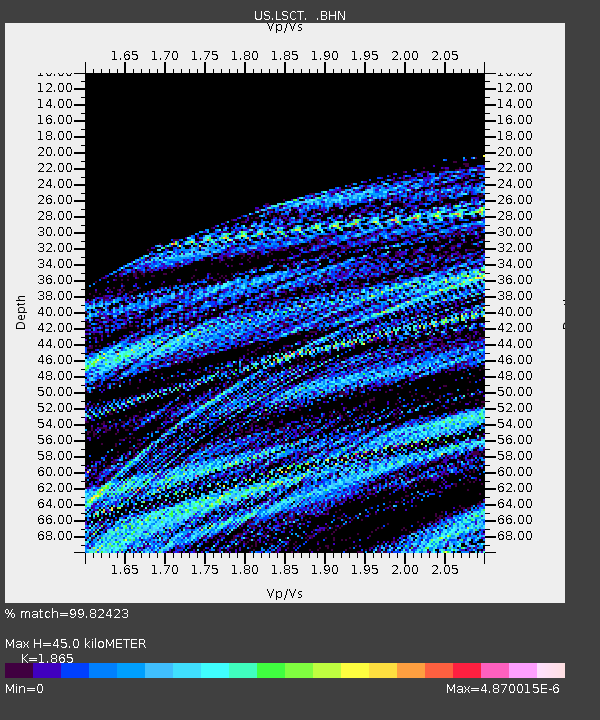
| Estimated Moho Depth: |
45.0 km |
| Estimated Crust Vp/Vs: |
1.87 |
| Assumed Crust Vp: |
6.472 km/s |
| Estimated Crust Vs: |
3.47 km/s |
| Estimated Crust Poisson's Ratio: |
0.30 |
|
| Radial Match: |
99.82423 % |
| Radial Bump: |
22 |
| Transverse Match: |
99.36488 % |
| Transverse Bump: |
32 |
| SOD ConfigId: |
110165 |
| Insert Time: |
2010-03-05 07:08:49.388 +0000 |
| GWidth: |
2.5 |
| Max Bumps: |
400 |
| Tol: |
0.001 |
|
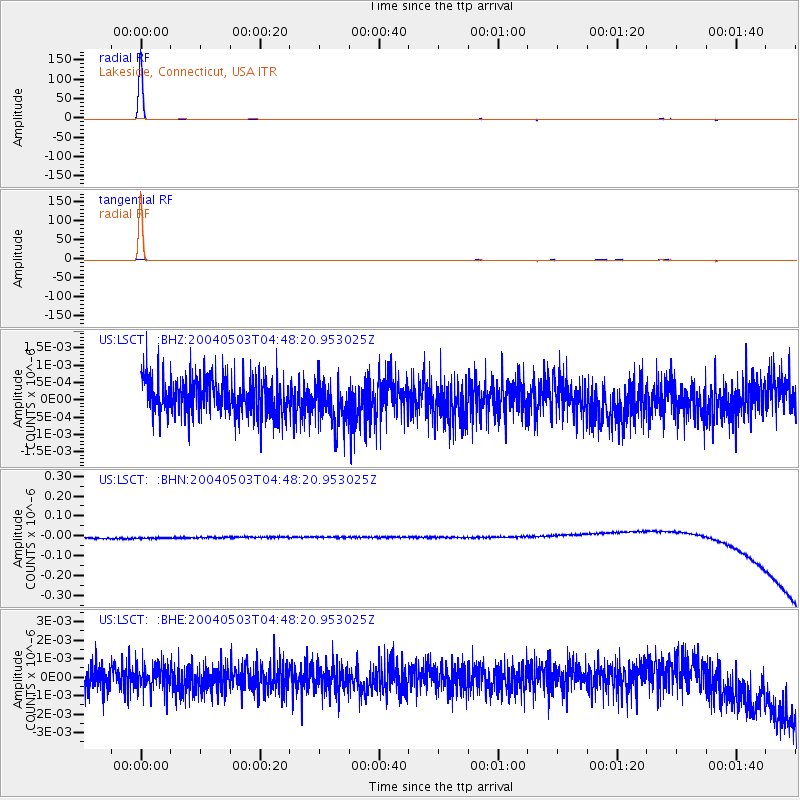
Signal To Noise
| Channel | StoN | STA | LTA |
| US:LSCT: :BHN:20040503T04:48:20.953025Z | 0.8915827 | 2.5127454E-8 | 2.8182974E-8 |
| US:LSCT: :BHE:20040503T04:48:20.953025Z | 0.8445024 | 6.4512085E-10 | 7.6390644E-10 |
| US:LSCT: :BHZ:20040503T04:48:20.953025Z | 1.2246318 | 6.3797223E-10 | 5.209503E-10 |
| Arrivals |
| Ps | 6.2 SECOND |
| PpPs | 19 SECOND |
| PsPs/PpSs | 26 SECOND |


