You are here: Home > Network List > CI - Caltech Regional Seismic Network Stations List
> Station MPM Manuel Prospect Mine, California, USA > Earthquake Result Viewer
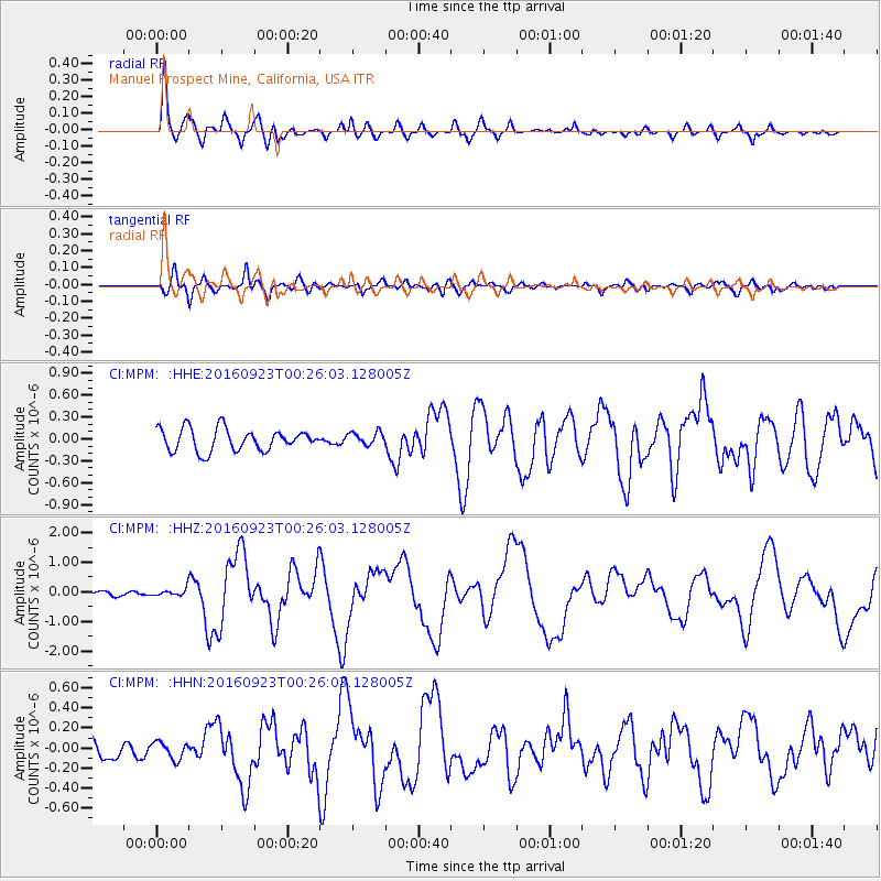
MPM Manuel Prospect Mine, California, USA - Earthquake Result Viewer
*The percent match for this event was below the threshold and hence no stack was calculated.
| Earthquake location: |
Off East Coast Of Honshu, Japan |
| Earthquake latitude/longitude: |
34.5/141.7 |
| Earthquake time(UTC): |
2016/09/23 (267) 00:14:33 GMT |
| Earthquake Depth: |
10 km |
| Earthquake Magnitude: |
6.4 MWP, 6.3 MWW |
| Earthquake Catalog/Contributor: |
NEIC PDE/NEIC COMCAT |
|
| Network: |
CI Caltech Regional Seismic Network |
| Station: |
MPM Manuel Prospect Mine, California, USA |
| Lat/Lon: |
36.06 N/117.49 W |
| Elevation: |
185 m |
|
| Distance: |
78.1 deg |
| Az: |
54.428 deg |
| Baz: |
303.998 deg |
| Ray Param: |
$rayparam |
*The percent match for this event was below the threshold and hence was not used in the summary stack. |
|
| Radial Match: |
84.872284 % |
| Radial Bump: |
400 |
| Transverse Match: |
70.5404 % |
| Transverse Bump: |
400 |
| SOD ConfigId: |
11737051 |
| Insert Time: |
2019-04-25 14:05:51.425 +0000 |
| GWidth: |
2.5 |
| Max Bumps: |
400 |
| Tol: |
0.001 |
|
Signal To Noise
| Channel | StoN | STA | LTA |
| CI:MPM: :HHZ:20160923T00:26:03.128005Z | 1.2848257 | 1.1207604E-7 | 8.723054E-8 |
| CI:MPM: :HHN:20160923T00:26:03.128005Z | 1.1464062 | 8.5693955E-8 | 7.475008E-8 |
| CI:MPM: :HHE:20160923T00:26:03.128005Z | 0.4435295 | 6.903936E-8 | 1.5565901E-7 |
| Arrivals |
| Ps | |
| PpPs | |
| PsPs/PpSs | |


