You are here: Home > Network List > CN - Canadian National Seismograph Network Stations List
> Station INK INUVIK, NT > Earthquake Result Viewer
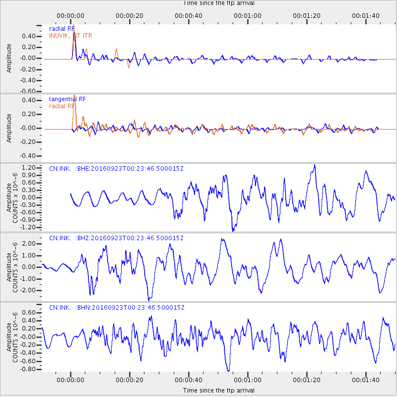
INK INUVIK, NT - Earthquake Result Viewer
*The percent match for this event was below the threshold and hence no stack was calculated.
| Earthquake location: |
Off East Coast Of Honshu, Japan |
| Earthquake latitude/longitude: |
34.5/141.7 |
| Earthquake time(UTC): |
2016/09/23 (267) 00:14:33 GMT |
| Earthquake Depth: |
10 km |
| Earthquake Magnitude: |
6.4 MWP, 6.3 MWW |
| Earthquake Catalog/Contributor: |
NEIC PDE/NEIC COMCAT |
|
| Network: |
CN Canadian National Seismograph Network |
| Station: |
INK INUVIK, NT |
| Lat/Lon: |
68.31 N/133.53 W |
| Elevation: |
44 m |
|
| Distance: |
56.5 deg |
| Az: |
26.35 deg |
| Baz: |
279.604 deg |
| Ray Param: |
$rayparam |
*The percent match for this event was below the threshold and hence was not used in the summary stack. |
|
| Radial Match: |
87.65959 % |
| Radial Bump: |
400 |
| Transverse Match: |
71.40776 % |
| Transverse Bump: |
400 |
| SOD ConfigId: |
11737051 |
| Insert Time: |
2019-04-25 14:06:21.554 +0000 |
| GWidth: |
2.5 |
| Max Bumps: |
400 |
| Tol: |
0.001 |
|
Signal To Noise
| Channel | StoN | STA | LTA |
| CN:INK: :BHZ:20160923T00:23:46.500015Z | 3.2317045 | 4.45604E-7 | 1.3788514E-7 |
| CN:INK: :BHN:20160923T00:23:46.500015Z | 1.0030189 | 1.344051E-7 | 1.3400057E-7 |
| CN:INK: :BHE:20160923T00:23:46.500015Z | 1.3995001 | 2.5275372E-7 | 1.8060287E-7 |
| Arrivals |
| Ps | |
| PpPs | |
| PsPs/PpSs | |


