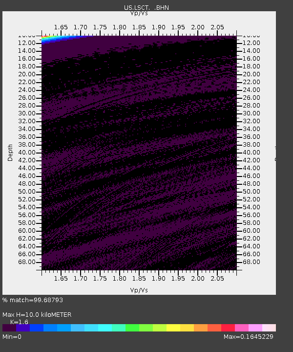
LSCT Lakeside, Connecticut, USA - Earthquake Result Viewer
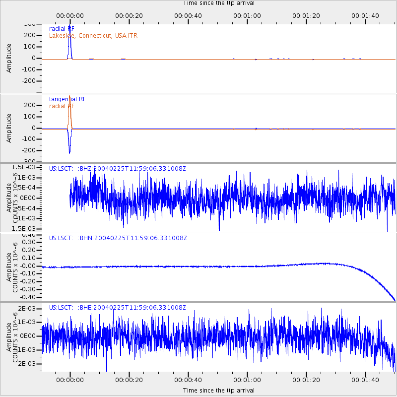
Earthquake location: Off Coast Of Chiapas, Mexico
Earthquake latitude/longitude: 14.0/-92.2
Earthquake time(UTC): 2004/02/25 (056) 11:53:12 GMT
Earthquake Depth: 31 km
Earthquake Magnitude: 4.8 MB, 5.1 MS, 5.5 MW, 5.5 MD
Earthquake Catalog/Contributor: WHDF/NEIC
Network: US United States National Seismic Network
Station: LSCT Lakeside, Connecticut, USA
Lat/Lon: 41.68 N/73.22 W
Elevation: 318 m
Distance: 32.1 deg
Az: 27.234 deg
Baz: 216.371 deg
Ray Param: 0.078735285
Estimated Moho Depth: 10.0 km
Estimated Crust Vp/Vs: 1.60
Assumed Crust Vp: 6.472 km/s
Estimated Crust Vs: 4.045 km/s
Estimated Crust Poisson's Ratio: 0.18
Radial Match: 99.68793 %
Radial Bump: 32
Transverse Match: 99.68716 %
Transverse Bump: 32
SOD ConfigId: 110165
Insert Time: 2010-03-05 07:09:03.686 +0000
GWidth: 2.5
Max Bumps: 400
Tol: 0.001

Signal To Noise

ChannelStoNSTALTA
US:LSCT: :BHN:20040225T11:59:06.331008Z0.91062863.2351682E-83.552676E-8
US:LSCT: :BHE:20040225T11:59:06.331008Z1.00817286.175878E-106.125813E-10
US:LSCT: :BHZ:20040225T11:59:06.331008Z0.82385814.0313772E-104.893291E-10
Arrivals
Ps1.0 SECOND
PpPs3.7 SECOND
PsPs/PpSs4.7 SECOND