You are here: Home > Network List > IU - Global Seismograph Network (GSN - IRIS/USGS) Stations List
> Station KBL Kabul, Afghanistan > Earthquake Result Viewer
KBL Kabul, Afghanistan - Earthquake Result Viewer
| Earthquake location: |
Sunda Strait, Indonesia |
| Earthquake latitude/longitude: |
-6.5/105.2 |
| Earthquake time(UTC): |
2009/10/16 (289) 09:52:50 GMT |
| Earthquake Depth: |
38 km |
| Earthquake Magnitude: |
5.9 MB, 5.8 MS, 6.1 MW, 6.1 MW |
| Earthquake Catalog/Contributor: |
WHDF/NEIC |
|
| Network: |
IU Global Seismograph Network (GSN - IRIS/USGS) |
| Station: |
KBL Kabul, Afghanistan |
| Lat/Lon: |
34.54 N/69.04 E |
| Elevation: |
1920 m |
|
| Distance: |
53.3 deg |
| Az: |
322.545 deg |
| Baz: |
132.948 deg |
| Ray Param: |
0.0661419 |
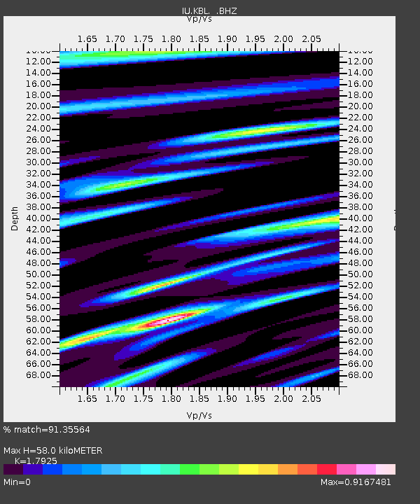
| Estimated Moho Depth: |
58.0 km |
| Estimated Crust Vp/Vs: |
1.79 |
| Assumed Crust Vp: |
6.641 km/s |
| Estimated Crust Vs: |
3.705 km/s |
| Estimated Crust Poisson's Ratio: |
0.27 |
|
| Radial Match: |
91.35564 % |
| Radial Bump: |
400 |
| Transverse Match: |
86.08457 % |
| Transverse Bump: |
400 |
| SOD ConfigId: |
1 |
| Insert Time: |
2010-02-19 00:50:09.975 +0000 |
| GWidth: |
2.5 |
| Max Bumps: |
400 |
| Tol: |
0.001 |
|
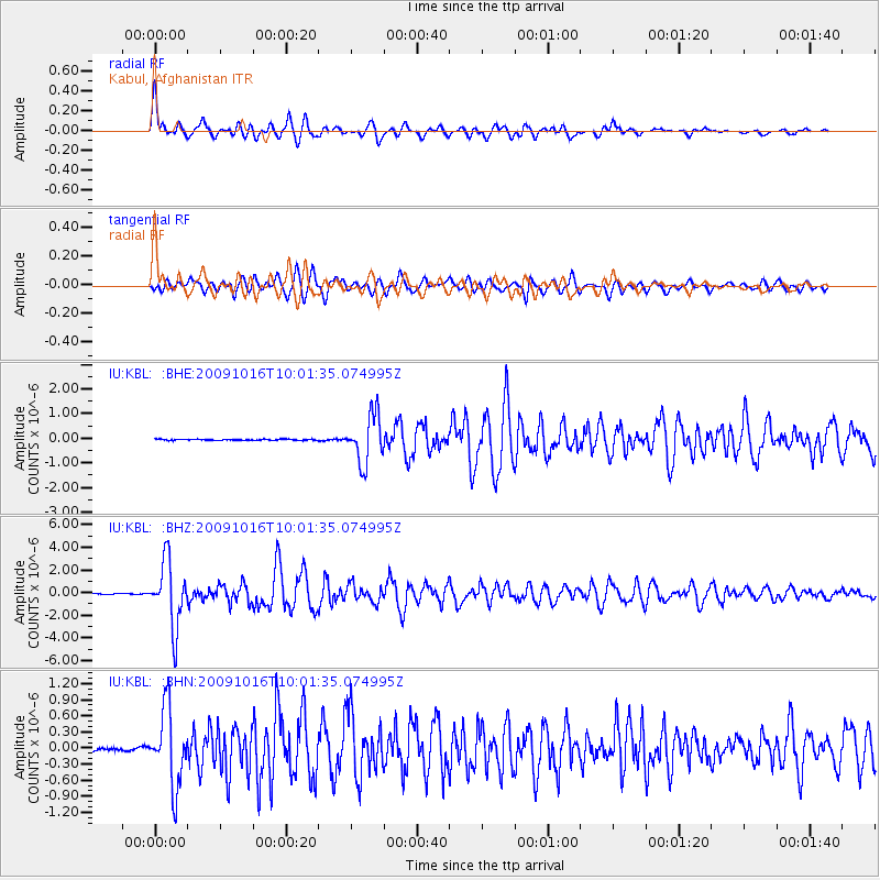
Signal To Noise
| Channel | StoN | STA | LTA |
| IU:KBL: :BHZ:20091016T10:01:35.074995Z | 49.31471 | 2.8520462E-6 | 5.7833578E-8 |
| IU:KBL: :BHN:20091016T10:01:35.074995Z | 21.255564 | 7.0078676E-7 | 3.296957E-8 |
| IU:KBL: :BHE:20091016T10:01:35.074995Z | 42.43438 | 9.670877E-7 | 2.2790193E-8 |
| Arrivals |
| Ps | 7.3 SECOND |
| PpPs | 23 SECOND |
| PsPs/PpSs | 30 SECOND |


