You are here: Home > Network List > MM - Myanmar National Seismic Network Stations List
> Station HKA Haka, Chin, Myanmar > Earthquake Result Viewer
HKA Haka, Chin, Myanmar - Earthquake Result Viewer
| Earthquake location: |
Off East Coast Of Honshu, Japan |
| Earthquake latitude/longitude: |
34.5/141.7 |
| Earthquake time(UTC): |
2016/09/23 (267) 00:14:33 GMT |
| Earthquake Depth: |
10 km |
| Earthquake Magnitude: |
6.4 MWP, 6.3 MWW |
| Earthquake Catalog/Contributor: |
NEIC PDE/NEIC COMCAT |
|
| Network: |
MM Myanmar National Seismic Network |
| Station: |
HKA Haka, Chin, Myanmar |
| Lat/Lon: |
22.64 N/93.60 E |
| Elevation: |
1733 m |
|
| Distance: |
43.5 deg |
| Az: |
267.388 deg |
| Baz: |
63.261 deg |
| Ray Param: |
0.072487384 |
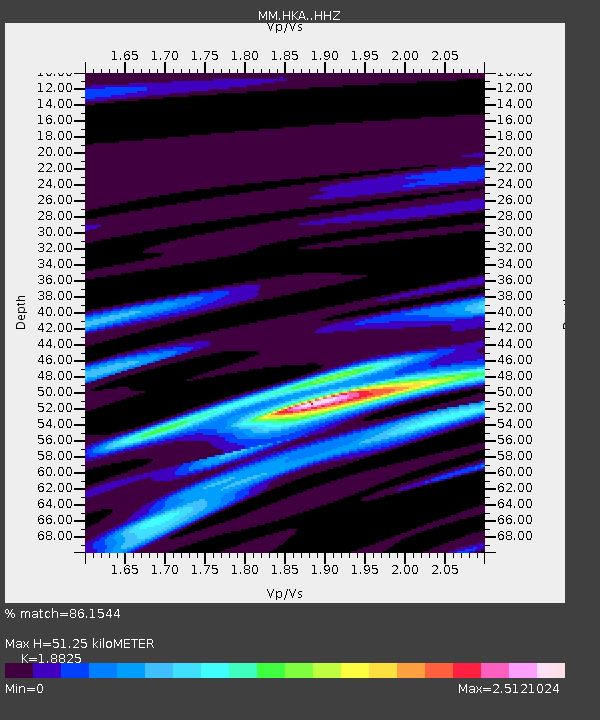
| Estimated Moho Depth: |
51.25 km |
| Estimated Crust Vp/Vs: |
1.88 |
| Assumed Crust Vp: |
6.552 km/s |
| Estimated Crust Vs: |
3.481 km/s |
| Estimated Crust Poisson's Ratio: |
0.30 |
|
| Radial Match: |
86.1544 % |
| Radial Bump: |
400 |
| Transverse Match: |
71.478264 % |
| Transverse Bump: |
400 |
| SOD ConfigId: |
11737051 |
| Insert Time: |
2019-04-25 14:09:10.504 +0000 |
| GWidth: |
2.5 |
| Max Bumps: |
400 |
| Tol: |
0.001 |
|

Signal To Noise
| Channel | StoN | STA | LTA |
| MM:HKA: :HHZ:20160923T00:22:06.837997Z | 12.41169 | 1.0911041E-6 | 8.790939E-8 |
| MM:HKA: :HHN:20160923T00:22:06.837997Z | 2.118605 | 1.9523438E-7 | 9.2152334E-8 |
| MM:HKA: :HHE:20160923T00:22:06.837997Z | 5.43051 | 5.255253E-7 | 9.677274E-8 |
| Arrivals |
| Ps | 7.4 SECOND |
| PpPs | 21 SECOND |
| PsPs/PpSs | 28 SECOND |


