You are here: Home > Network List > US - United States National Seismic Network Stations List
> Station LSCT Lakeside, Connecticut, USA > Earthquake Result Viewer
LSCT Lakeside, Connecticut, USA - Earthquake Result Viewer
| Earthquake location: |
Off Coast Of Central Chile |
| Earthquake latitude/longitude: |
-33.1/-72.8 |
| Earthquake time(UTC): |
2005/04/13 (103) 09:25:27 GMT |
| Earthquake Depth: |
30 km |
| Earthquake Magnitude: |
5.6 MB, 4.7 MS, 5.4 MW, 5.4 MW |
| Earthquake Catalog/Contributor: |
WHDF/NEIC |
|
| Network: |
US United States National Seismic Network |
| Station: |
LSCT Lakeside, Connecticut, USA |
| Lat/Lon: |
41.68 N/73.22 W |
| Elevation: |
318 m |
|
| Distance: |
74.5 deg |
| Az: |
359.709 deg |
| Baz: |
179.674 deg |
| Ray Param: |
0.05228125 |
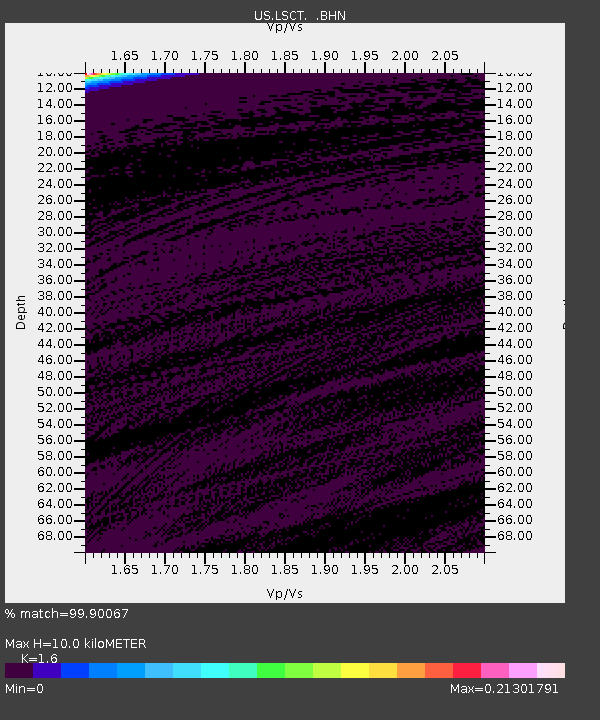
| Estimated Moho Depth: |
10.0 km |
| Estimated Crust Vp/Vs: |
1.60 |
| Assumed Crust Vp: |
6.472 km/s |
| Estimated Crust Vs: |
4.045 km/s |
| Estimated Crust Poisson's Ratio: |
0.18 |
|
| Radial Match: |
99.90067 % |
| Radial Bump: |
16 |
| Transverse Match: |
99.21064 % |
| Transverse Bump: |
47 |
| SOD ConfigId: |
110165 |
| Insert Time: |
2010-03-05 07:09:07.447 +0000 |
| GWidth: |
2.5 |
| Max Bumps: |
400 |
| Tol: |
0.001 |
|
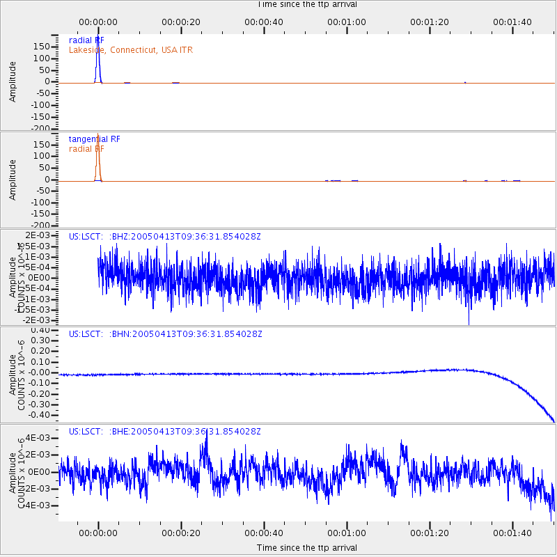
Signal To Noise
| Channel | StoN | STA | LTA |
| US:LSCT: :BHN:20050413T09:36:31.854028Z | 0.9120966 | 3.3441097E-8 | 3.6663987E-8 |
| US:LSCT: :BHE:20050413T09:36:31.854028Z | 0.7356876 | 1.0941418E-9 | 1.4872369E-9 |
| US:LSCT: :BHZ:20050413T09:36:31.854028Z | 1.047746 | 5.8652594E-10 | 5.597979E-10 |
| Arrivals |
| Ps | 1.0 SECOND |
| PpPs | 3.9 SECOND |
| PsPs/PpSs | 4.8 SECOND |


