You are here: Home > Network List > US - United States National Seismic Network Stations List
> Station LSCT Lakeside, Connecticut, USA > Earthquake Result Viewer
LSCT Lakeside, Connecticut, USA - Earthquake Result Viewer
| Earthquake location: |
Northern Peru |
| Earthquake latitude/longitude: |
-7.3/-77.9 |
| Earthquake time(UTC): |
2005/04/11 (101) 14:54:07 GMT |
| Earthquake Depth: |
130 km |
| Earthquake Magnitude: |
6.1 MB, 6.0 MW, 5.9 MW |
| Earthquake Catalog/Contributor: |
WHDF/NEIC |
|
| Network: |
US United States National Seismic Network |
| Station: |
LSCT Lakeside, Connecticut, USA |
| Lat/Lon: |
41.68 N/73.22 W |
| Elevation: |
318 m |
|
| Distance: |
48.9 deg |
| Az: |
4.633 deg |
| Baz: |
186.14 deg |
| Ray Param: |
0.06859137 |
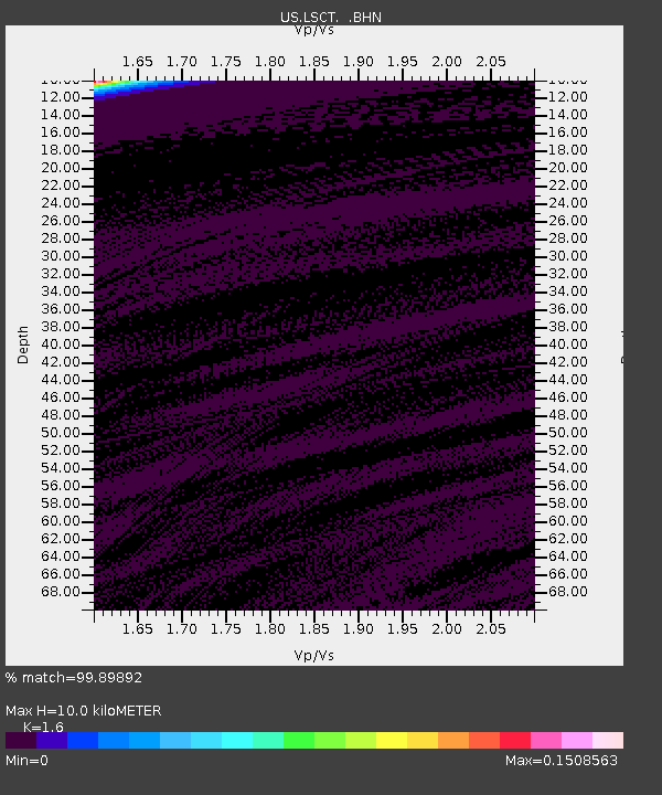
| Estimated Moho Depth: |
10.0 km |
| Estimated Crust Vp/Vs: |
1.60 |
| Assumed Crust Vp: |
6.472 km/s |
| Estimated Crust Vs: |
4.045 km/s |
| Estimated Crust Poisson's Ratio: |
0.18 |
|
| Radial Match: |
99.89892 % |
| Radial Bump: |
15 |
| Transverse Match: |
99.904045 % |
| Transverse Bump: |
14 |
| SOD ConfigId: |
110165 |
| Insert Time: |
2010-03-05 07:09:09.025 +0000 |
| GWidth: |
2.5 |
| Max Bumps: |
400 |
| Tol: |
0.001 |
|
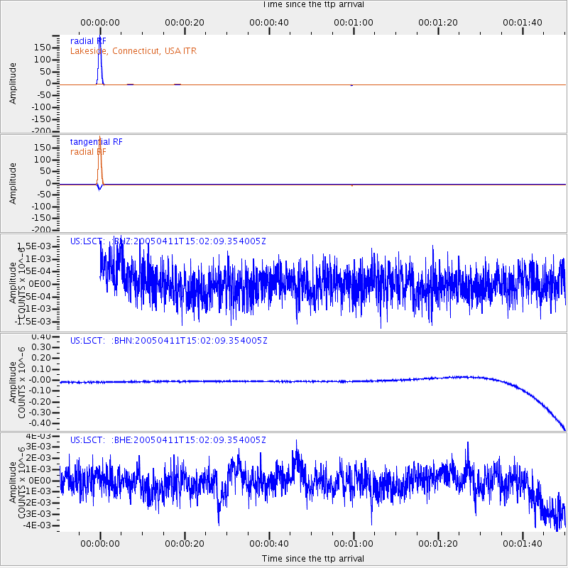
Signal To Noise
| Channel | StoN | STA | LTA |
| US:LSCT: :BHN:20050411T15:02:09.354005Z | 0.916811 | 3.3555345E-8 | 3.660007E-8 |
| US:LSCT: :BHE:20050411T15:02:09.354005Z | 0.9609472 | 8.915034E-10 | 9.2773406E-10 |
| US:LSCT: :BHZ:20050411T15:02:09.354005Z | 1.0465432 | 6.642375E-10 | 6.3469663E-10 |
| Arrivals |
| Ps | 1.0 SECOND |
| PpPs | 3.8 SECOND |
| PsPs/PpSs | 4.8 SECOND |


