You are here: Home > Network List > US - United States National Seismic Network Stations List
> Station LSCT Lakeside, Connecticut, USA > Earthquake Result Viewer
LSCT Lakeside, Connecticut, USA - Earthquake Result Viewer
| Earthquake location: |
Southern East Pacific Rise |
| Earthquake latitude/longitude: |
-34.9/-107.9 |
| Earthquake time(UTC): |
2005/02/28 (059) 01:24:54 GMT |
| Earthquake Depth: |
10 km |
| Earthquake Magnitude: |
5.1 MB, 5.3 MS, 5.9 MW |
| Earthquake Catalog/Contributor: |
WHDF/NEIC |
|
| Network: |
US United States National Seismic Network |
| Station: |
LSCT Lakeside, Connecticut, USA |
| Lat/Lon: |
41.68 N/73.22 W |
| Elevation: |
318 m |
|
| Distance: |
82.6 deg |
| Az: |
25.429 deg |
| Baz: |
208.1 deg |
| Ray Param: |
0.04677944 |
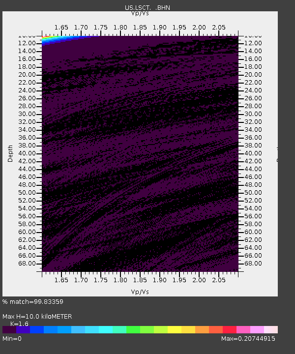
| Estimated Moho Depth: |
10.0 km |
| Estimated Crust Vp/Vs: |
1.60 |
| Assumed Crust Vp: |
6.472 km/s |
| Estimated Crust Vs: |
4.045 km/s |
| Estimated Crust Poisson's Ratio: |
0.18 |
|
| Radial Match: |
99.83359 % |
| Radial Bump: |
14 |
| Transverse Match: |
99.84885 % |
| Transverse Bump: |
13 |
| SOD ConfigId: |
110165 |
| Insert Time: |
2010-03-05 07:09:12.388 +0000 |
| GWidth: |
2.5 |
| Max Bumps: |
400 |
| Tol: |
0.001 |
|
Signal To Noise
| Channel | StoN | STA | LTA |
| US:LSCT: :BHN:20050228T01:36:46.408018Z | 0.9123497 | 3.3442735E-8 | 3.665561E-8 |
| US:LSCT: :BHE:20050228T01:36:46.408018Z | 1.4211836 | 2.1111575E-9 | 1.4854924E-9 |
| US:LSCT: :BHZ:20050228T01:36:46.408018Z | 1.1874095 | 7.272033E-10 | 6.124284E-10 |
| Arrivals |
| Ps | 1.0 SECOND |
| PpPs | 3.9 SECOND |
| PsPs/PpSs | 4.9 SECOND |


