You are here: Home > Network List > US - United States National Seismic Network Stations List
> Station LSCT Lakeside, Connecticut, USA > Earthquake Result Viewer
LSCT Lakeside, Connecticut, USA - Earthquake Result Viewer
| Earthquake location: |
Southern East Pacific Rise |
| Earthquake latitude/longitude: |
-20.9/-113.7 |
| Earthquake time(UTC): |
2005/02/24 (055) 04:55:50 GMT |
| Earthquake Depth: |
10 km |
| Earthquake Magnitude: |
5.5 MB, 5.3 MS, 5.7 MW, 5.7 MW |
| Earthquake Catalog/Contributor: |
WHDF/NEIC |
|
| Network: |
US United States National Seismic Network |
| Station: |
LSCT Lakeside, Connecticut, USA |
| Lat/Lon: |
41.68 N/73.22 W |
| Elevation: |
318 m |
|
| Distance: |
72.6 deg |
| Az: |
30.611 deg |
| Baz: |
219.467 deg |
| Ray Param: |
0.05352254 |
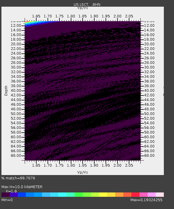
| Estimated Moho Depth: |
10.0 km |
| Estimated Crust Vp/Vs: |
1.60 |
| Assumed Crust Vp: |
6.472 km/s |
| Estimated Crust Vs: |
4.045 km/s |
| Estimated Crust Poisson's Ratio: |
0.18 |
|
| Radial Match: |
99.7878 % |
| Radial Bump: |
22 |
| Transverse Match: |
99.80976 % |
| Transverse Bump: |
24 |
| SOD ConfigId: |
110165 |
| Insert Time: |
2010-03-05 07:09:14.471 +0000 |
| GWidth: |
2.5 |
| Max Bumps: |
400 |
| Tol: |
0.001 |
|
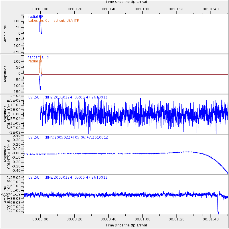
Signal To Noise
| Channel | StoN | STA | LTA |
| US:LSCT: :BHN:20050224T05:06:47.261001Z | 0.9140773 | 3.3308254E-8 | 3.643921E-8 |
| US:LSCT: :BHE:20050224T05:06:47.261001Z | 1.0895325 | 8.9041374E-10 | 8.172439E-10 |
| US:LSCT: :BHZ:20050224T05:06:47.261001Z | 1.0881939 | 6.4234595E-10 | 5.9028626E-10 |
| Arrivals |
| Ps | 1.0 SECOND |
| PpPs | 3.9 SECOND |
| PsPs/PpSs | 4.8 SECOND |


