You are here: Home > Network List > US - United States National Seismic Network Stations List
> Station LSCT Lakeside, Connecticut, USA > Earthquake Result Viewer
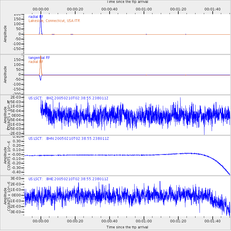
LSCT Lakeside, Connecticut, USA - Earthquake Result Viewer
| Earthquake location: |
South Of Panama |
| Earthquake latitude/longitude: |
5.3/-82.6 |
| Earthquake time(UTC): |
2005/02/10 (041) 02:32:14 GMT |
| Earthquake Depth: |
10 km |
| Earthquake Magnitude: |
5.3 MB, 5.2 MS, 5.8 MW, 5.7 MW |
| Earthquake Catalog/Contributor: |
WHDF/NEIC |
|
| Network: |
US United States National Seismic Network |
| Station: |
LSCT Lakeside, Connecticut, USA |
| Lat/Lon: |
41.68 N/73.22 W |
| Elevation: |
318 m |
|
| Distance: |
37.2 deg |
| Az: |
11.674 deg |
| Baz: |
195.605 deg |
| Ray Param: |
0.076257624 |
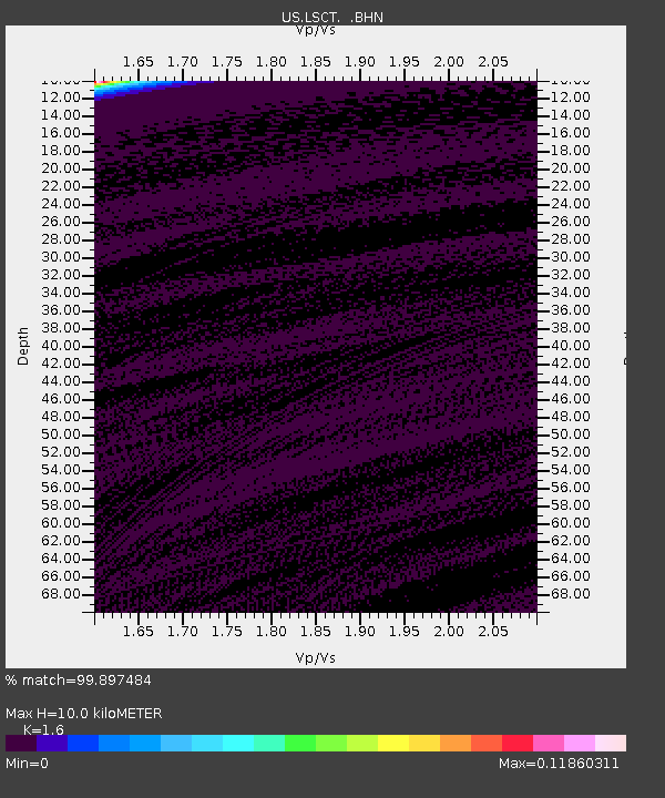
| Estimated Moho Depth: |
10.0 km |
| Estimated Crust Vp/Vs: |
1.60 |
| Assumed Crust Vp: |
6.472 km/s |
| Estimated Crust Vs: |
4.045 km/s |
| Estimated Crust Poisson's Ratio: |
0.18 |
|
| Radial Match: |
99.897484 % |
| Radial Bump: |
12 |
| Transverse Match: |
99.89829 % |
| Transverse Bump: |
12 |
| SOD ConfigId: |
110165 |
| Insert Time: |
2010-03-05 07:09:20.176 +0000 |
| GWidth: |
2.5 |
| Max Bumps: |
400 |
| Tol: |
0.001 |
|
Signal To Noise
| Channel | StoN | STA | LTA |
| US:LSCT: :BHN:20050210T02:38:55.238011Z | 0.910619 | 3.3179443E-8 | 3.643614E-8 |
| US:LSCT: :BHE:20050210T02:38:55.238011Z | 0.95855826 | 8.3364987E-10 | 8.696914E-10 |
| US:LSCT: :BHZ:20050210T02:38:55.238011Z | 1.0718966 | 6.206408E-10 | 5.7901184E-10 |
| Arrivals |
| Ps | 1.0 SECOND |
| PpPs | 3.7 SECOND |
| PsPs/PpSs | 4.7 SECOND |


