You are here: Home > Network List > US - United States National Seismic Network Stations List
> Station LSCT Lakeside, Connecticut, USA > Earthquake Result Viewer
LSCT Lakeside, Connecticut, USA - Earthquake Result Viewer
| Earthquake location: |
Off Coast Of Ecuador |
| Earthquake latitude/longitude: |
-1.2/-81.5 |
| Earthquake time(UTC): |
2005/01/28 (028) 09:26:18 GMT |
| Earthquake Depth: |
10 km |
| Earthquake Magnitude: |
5.2 MB, 5.6 MS, 6.1 MW, 6.0 MW |
| Earthquake Catalog/Contributor: |
WHDF/NEIC |
|
| Network: |
US United States National Seismic Network |
| Station: |
LSCT Lakeside, Connecticut, USA |
| Lat/Lon: |
41.68 N/73.22 W |
| Elevation: |
318 m |
|
| Distance: |
43.3 deg |
| Az: |
9.041 deg |
| Baz: |
192.107 deg |
| Ray Param: |
0.07262991 |
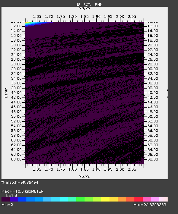
| Estimated Moho Depth: |
10.0 km |
| Estimated Crust Vp/Vs: |
1.60 |
| Assumed Crust Vp: |
6.472 km/s |
| Estimated Crust Vs: |
4.045 km/s |
| Estimated Crust Poisson's Ratio: |
0.18 |
|
| Radial Match: |
99.86494 % |
| Radial Bump: |
17 |
| Transverse Match: |
99.8648 % |
| Transverse Bump: |
17 |
| SOD ConfigId: |
110165 |
| Insert Time: |
2010-03-05 07:09:24.364 +0000 |
| GWidth: |
2.5 |
| Max Bumps: |
400 |
| Tol: |
0.001 |
|
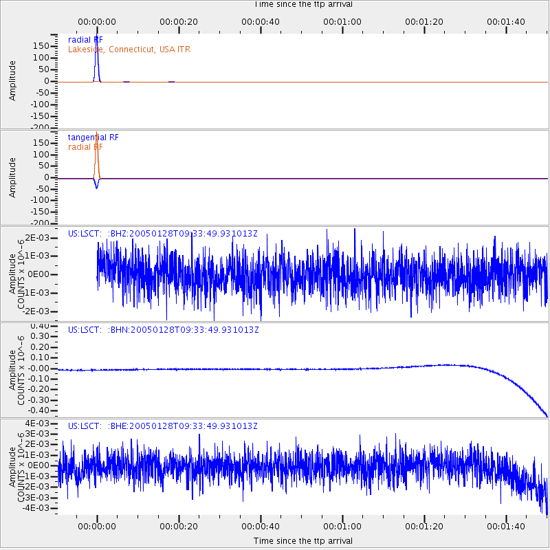
Signal To Noise
| Channel | StoN | STA | LTA |
| US:LSCT: :BHN:20050128T09:33:49.931013Z | 0.92232955 | 3.3535162E-8 | 3.6359197E-8 |
| US:LSCT: :BHE:20050128T09:33:49.931013Z | 0.9488696 | 8.8278784E-10 | 9.303574E-10 |
| US:LSCT: :BHZ:20050128T09:33:49.931013Z | 0.82775176 | 6.4236494E-10 | 7.7603574E-10 |
| Arrivals |
| Ps | 1.0 SECOND |
| PpPs | 3.7 SECOND |
| PsPs/PpSs | 4.7 SECOND |


