You are here: Home > Network List > TA - USArray Transportable Network (new EarthScope stations) Stations List
> Station F26K Sheenjek River, AK, USA > Earthquake Result Viewer
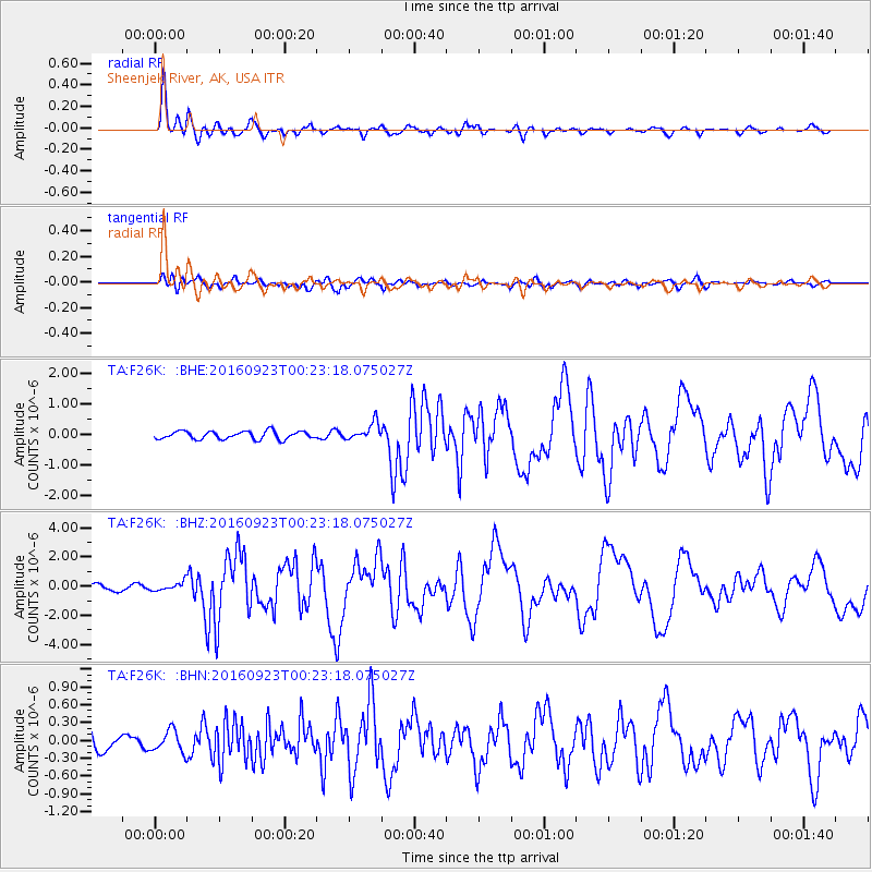
F26K Sheenjek River, AK, USA - Earthquake Result Viewer
*The percent match for this event was below the threshold and hence no stack was calculated.
| Earthquake location: |
Off East Coast Of Honshu, Japan |
| Earthquake latitude/longitude: |
34.5/141.7 |
| Earthquake time(UTC): |
2016/09/23 (267) 00:14:33 GMT |
| Earthquake Depth: |
10 km |
| Earthquake Magnitude: |
6.4 MWP, 6.3 MWW |
| Earthquake Catalog/Contributor: |
NEIC PDE/NEIC COMCAT |
|
| Network: |
TA USArray Transportable Network (new EarthScope stations) |
| Station: |
F26K Sheenjek River, AK, USA |
| Lat/Lon: |
67.69 N/144.15 W |
| Elevation: |
683 m |
|
| Distance: |
52.6 deg |
| Az: |
27.528 deg |
| Baz: |
270.446 deg |
| Ray Param: |
$rayparam |
*The percent match for this event was below the threshold and hence was not used in the summary stack. |
|
| Radial Match: |
93.80695 % |
| Radial Bump: |
400 |
| Transverse Match: |
72.69158 % |
| Transverse Bump: |
400 |
| SOD ConfigId: |
11737051 |
| Insert Time: |
2019-04-25 14:12:26.908 +0000 |
| GWidth: |
2.5 |
| Max Bumps: |
400 |
| Tol: |
0.001 |
|
Signal To Noise
| Channel | StoN | STA | LTA |
| TA:F26K: :BHZ:20160923T00:23:18.075027Z | 0.97074795 | 2.965716E-7 | 3.0550834E-7 |
| TA:F26K: :BHN:20160923T00:23:18.075027Z | 0.84638673 | 1.7999537E-7 | 2.1266327E-7 |
| TA:F26K: :BHE:20160923T00:23:18.075027Z | 0.99313545 | 1.3335345E-7 | 1.342752E-7 |
| Arrivals |
| Ps | |
| PpPs | |
| PsPs/PpSs | |


