You are here: Home > Network List > TA - USArray Transportable Network (new EarthScope stations) Stations List
> Station POKR Poker Plat Research Range, AK, USA > Earthquake Result Viewer
POKR Poker Plat Research Range, AK, USA - Earthquake Result Viewer

| Earthquake location: |
Irian Jaya Region, Indonesia |
| Earthquake latitude/longitude: |
-0.6/131.3 |
| Earthquake time(UTC): |
2015/09/24 (267) 15:53:28 GMT |
| Earthquake Depth: |
24 km |
| Earthquake Magnitude: |
6.6 MWW, 6.4 MWB, 6.9 MI |
| Earthquake Catalog/Contributor: |
NEIC PDE/NEIC COMCAT |
|
| Network: |
TA USArray Transportable Network (new EarthScope stations) |
| Station: |
POKR Poker Plat Research Range, AK, USA |
| Lat/Lon: |
65.12 N/147.43 W |
| Elevation: |
501 m |
|
| Distance: |
86.9 deg |
| Az: |
24.762 deg |
| Baz: |
261.855 deg |
| Ray Param: |
0.04368695 |
| Estimated Moho Depth: |
18.25 km |
| Estimated Crust Vp/Vs: |
1.60 |
| Assumed Crust Vp: |
6.566 km/s |
| Estimated Crust Vs: |
4.104 km/s |
| Estimated Crust Poisson's Ratio: |
0.18 |
|
| Radial Match: |
91.617386 % |
| Radial Bump: |
400 |
| Transverse Match: |
70.51377 % |
| Transverse Bump: |
400 |
| SOD ConfigId: |
1156111 |
| Insert Time: |
2015-10-08 16:25:53.694 +0000 |
| GWidth: |
2.5 |
| Max Bumps: |
400 |
| Tol: |
0.001 |
|
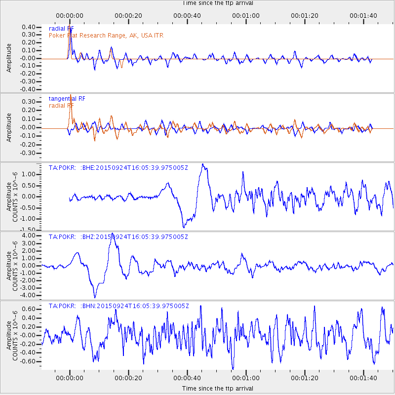
Signal To Noise
| Channel | StoN | STA | LTA |
| TA:POKR: :BHZ:20150924T16:05:39.975005Z | 14.314569 | 1.0982028E-6 | 7.671924E-8 |
| TA:POKR: :BHN:20150924T16:05:39.975005Z | 2.5249412 | 2.2013E-7 | 8.718223E-8 |
| TA:POKR: :BHE:20150924T16:05:39.975005Z | 4.8016934 | 3.767859E-7 | 7.846938E-8 |
| Arrivals |
| Ps | 1.7 SECOND |
| PpPs | 7.0 SECOND |
| PsPs/PpSs | 8.7 SECOND |


