You are here: Home > Network List > US - United States National Seismic Network Stations List
> Station MSO Missoula, Montana, USA > Earthquake Result Viewer
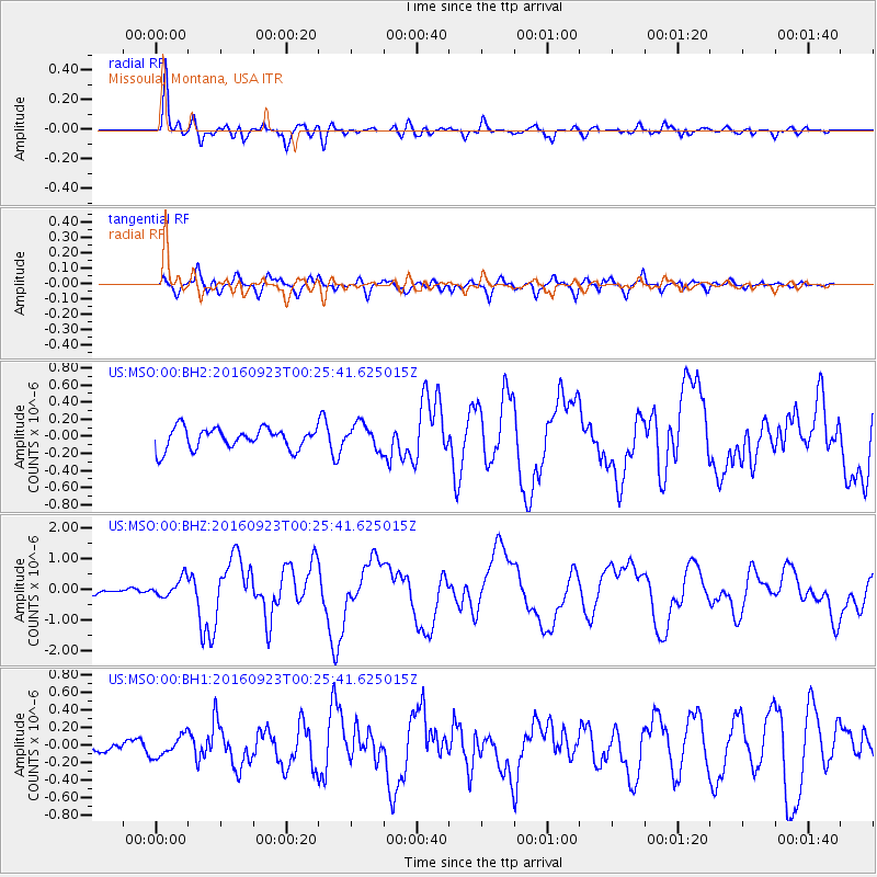
MSO Missoula, Montana, USA - Earthquake Result Viewer
*The percent match for this event was below the threshold and hence no stack was calculated.
| Earthquake location: |
Off East Coast Of Honshu, Japan |
| Earthquake latitude/longitude: |
34.5/141.7 |
| Earthquake time(UTC): |
2016/09/23 (267) 00:14:33 GMT |
| Earthquake Depth: |
10 km |
| Earthquake Magnitude: |
6.4 MWP, 6.3 MWW |
| Earthquake Catalog/Contributor: |
NEIC PDE/NEIC COMCAT |
|
| Network: |
US United States National Seismic Network |
| Station: |
MSO Missoula, Montana, USA |
| Lat/Lon: |
46.83 N/113.94 W |
| Elevation: |
1264 m |
|
| Distance: |
74.4 deg |
| Az: |
43.702 deg |
| Baz: |
303.791 deg |
| Ray Param: |
$rayparam |
*The percent match for this event was below the threshold and hence was not used in the summary stack. |
|
| Radial Match: |
80.68382 % |
| Radial Bump: |
400 |
| Transverse Match: |
69.96871 % |
| Transverse Bump: |
400 |
| SOD ConfigId: |
11737051 |
| Insert Time: |
2019-04-25 14:13:40.584 +0000 |
| GWidth: |
2.5 |
| Max Bumps: |
400 |
| Tol: |
0.001 |
|
Signal To Noise
| Channel | StoN | STA | LTA |
| US:MSO:00:BHZ:20160923T00:25:41.625015Z | 2.7576022 | 3.134059E-7 | 1.136516E-7 |
| US:MSO:00:BH1:20160923T00:25:41.625015Z | 1.030487 | 1.16956734E-7 | 1.13496576E-7 |
| US:MSO:00:BH2:20160923T00:25:41.625015Z | 1.2880555 | 1.5928353E-7 | 1.2366199E-7 |
| Arrivals |
| Ps | |
| PpPs | |
| PsPs/PpSs | |


