You are here: Home > Network List > UW - Pacific Northwest Regional Seismic Network Stations List
> Station PASS Maple Falls, WA, USA > Earthquake Result Viewer
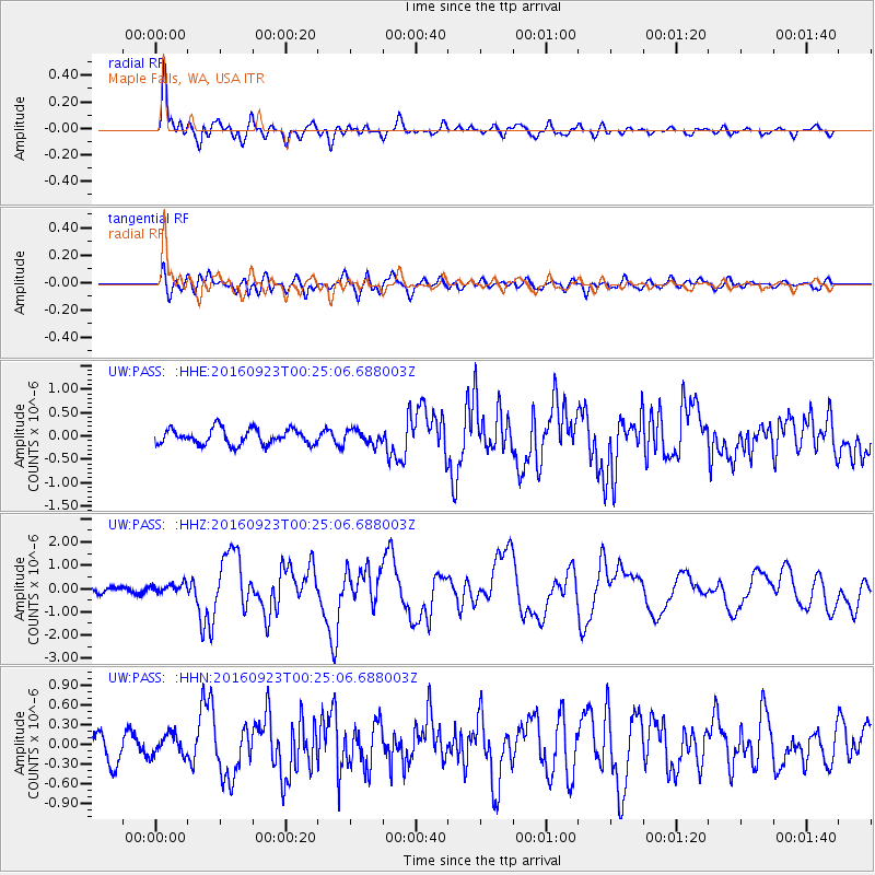
PASS Maple Falls, WA, USA - Earthquake Result Viewer
*The percent match for this event was below the threshold and hence no stack was calculated.
| Earthquake location: |
Off East Coast Of Honshu, Japan |
| Earthquake latitude/longitude: |
34.5/141.7 |
| Earthquake time(UTC): |
2016/09/23 (267) 00:14:33 GMT |
| Earthquake Depth: |
10 km |
| Earthquake Magnitude: |
6.4 MWP, 6.3 MWW |
| Earthquake Catalog/Contributor: |
NEIC PDE/NEIC COMCAT |
|
| Network: |
UW Pacific Northwest Regional Seismic Network |
| Station: |
PASS Maple Falls, WA, USA |
| Lat/Lon: |
49.00 N/122.09 W |
| Elevation: |
174 m |
|
| Distance: |
68.5 deg |
| Az: |
44.712 deg |
| Baz: |
298.081 deg |
| Ray Param: |
$rayparam |
*The percent match for this event was below the threshold and hence was not used in the summary stack. |
|
| Radial Match: |
84.91622 % |
| Radial Bump: |
400 |
| Transverse Match: |
71.42553 % |
| Transverse Bump: |
400 |
| SOD ConfigId: |
11737051 |
| Insert Time: |
2019-04-25 14:14:11.725 +0000 |
| GWidth: |
2.5 |
| Max Bumps: |
400 |
| Tol: |
0.001 |
|
Signal To Noise
| Channel | StoN | STA | LTA |
| UW:PASS: :HHZ:20160923T00:25:06.688003Z | 1.6428088 | 2.1287552E-7 | 1.2958022E-7 |
| UW:PASS: :HHN:20160923T00:25:06.688003Z | 0.91656905 | 1.6175211E-7 | 1.7647564E-7 |
| UW:PASS: :HHE:20160923T00:25:06.688003Z | 0.9273636 | 1.52125E-7 | 1.640403E-7 |
| Arrivals |
| Ps | |
| PpPs | |
| PsPs/PpSs | |


