You are here: Home > Network List > CI - Caltech Regional Seismic Network Stations List
> Station PLM Palomar, California, USA > Earthquake Result Viewer
PLM Palomar, California, USA - Earthquake Result Viewer
| Earthquake location: |
South Of Alaska |
| Earthquake latitude/longitude: |
53.8/-161.1 |
| Earthquake time(UTC): |
2002/05/25 (145) 05:36:31 GMT |
| Earthquake Depth: |
33 km |
| Earthquake Magnitude: |
5.5 MB, 6.1 MS, 6.5 MW, 6.4 MW |
| Earthquake Catalog/Contributor: |
WHDF/NEIC |
|
| Network: |
CI Caltech Regional Seismic Network |
| Station: |
PLM Palomar, California, USA |
| Lat/Lon: |
33.35 N/116.86 W |
| Elevation: |
1660 m |
|
| Distance: |
37.2 deg |
| Az: |
105.158 deg |
| Baz: |
316.857 deg |
| Ray Param: |
0.07618394 |
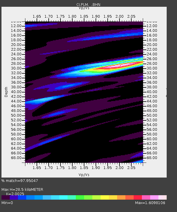
| Estimated Moho Depth: |
28.5 km |
| Estimated Crust Vp/Vs: |
2.00 |
| Assumed Crust Vp: |
6.264 km/s |
| Estimated Crust Vs: |
3.128 km/s |
| Estimated Crust Poisson's Ratio: |
0.33 |
|
| Radial Match: |
97.95047 % |
| Radial Bump: |
256 |
| Transverse Match: |
89.29702 % |
| Transverse Bump: |
400 |
| SOD ConfigId: |
3787 |
| Insert Time: |
2010-02-26 00:45:21.094 +0000 |
| GWidth: |
2.5 |
| Max Bumps: |
400 |
| Tol: |
0.001 |
|

Signal To Noise
| Channel | StoN | STA | LTA |
| CI:PLM: :BHN:20020525T05:43:10.00299Z | 1.0480554 | 1.4605472E-7 | 1.3935782E-7 |
| CI:PLM: :BHE:20020525T05:43:10.00299Z | 2.3807147 | 1.583598E-7 | 6.651776E-8 |
| CI:PLM: :BHZ:20020525T05:43:10.00299Z | 3.906978 | 2.5969746E-7 | 6.6470164E-8 |
| Arrivals |
| Ps | 4.9 SECOND |
| PpPs | 13 SECOND |
| PsPs/PpSs | 18 SECOND |


