You are here: Home > Network List > US - United States National Seismic Network Stations List
> Station LAO LASA Array, Montana, USA > Earthquake Result Viewer
LAO LASA Array, Montana, USA - Earthquake Result Viewer
| Earthquake location: |
Near S. Coast Of Western Honshu |
| Earthquake latitude/longitude: |
33.1/136.6 |
| Earthquake time(UTC): |
2004/09/05 (249) 10:07:07 GMT |
| Earthquake Depth: |
14 km |
| Earthquake Magnitude: |
6.7 MB, 7.0 MS, 7.2 MW, 7.0 MW |
| Earthquake Catalog/Contributor: |
WHDF/NEIC |
|
| Network: |
US United States National Seismic Network |
| Station: |
LAO LASA Array, Montana, USA |
| Lat/Lon: |
46.69 N/106.22 W |
| Elevation: |
902 m |
|
| Distance: |
82.5 deg |
| Az: |
38.152 deg |
| Baz: |
311.106 deg |
| Ray Param: |
0.046819028 |
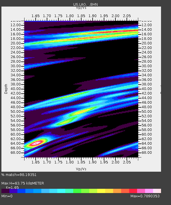
| Estimated Moho Depth: |
63.75 km |
| Estimated Crust Vp/Vs: |
1.65 |
| Assumed Crust Vp: |
6.438 km/s |
| Estimated Crust Vs: |
3.902 km/s |
| Estimated Crust Poisson's Ratio: |
0.21 |
|
| Radial Match: |
98.19351 % |
| Radial Bump: |
317 |
| Transverse Match: |
96.293144 % |
| Transverse Bump: |
332 |
| SOD ConfigId: |
110177 |
| Insert Time: |
2010-03-05 07:09:53.754 +0000 |
| GWidth: |
2.5 |
| Max Bumps: |
400 |
| Tol: |
0.001 |
|

Signal To Noise
| Channel | StoN | STA | LTA |
| US:LAO: :BHN:20040905T10:18:58.543022Z | 3.7324843 | 1.0639673E-6 | 2.8505607E-7 |
| US:LAO: :BHE:20040905T10:18:58.543022Z | 12.106333 | 4.5568445E-6 | 3.7640174E-7 |
| US:LAO: :BHZ:20040905T10:18:58.543022Z | 76.97959 | 1.62041E-5 | 2.1049864E-7 |
| Arrivals |
| Ps | 6.6 SECOND |
| PpPs | 26 SECOND |
| PsPs/PpSs | 32 SECOND |


