You are here: Home > Network List > IW - Intermountain West Stations List
> Station MOOW Moose Ponds, Wyoming, USA > Earthquake Result Viewer
MOOW Moose Ponds, Wyoming, USA - Earthquake Result Viewer
*The percent match for this event was below the threshold and hence no stack was calculated.
| Earthquake location: |
Solomon Islands |
| Earthquake latitude/longitude: |
-10.1/160.5 |
| Earthquake time(UTC): |
2015/09/24 (267) 15:56:57 GMT |
| Earthquake Depth: |
23 km |
| Earthquake Magnitude: |
6.0 MB |
| Earthquake Catalog/Contributor: |
NEIC PDE/NEIC COMCAT |
|
| Network: |
IW Intermountain West |
| Station: |
MOOW Moose Ponds, Wyoming, USA |
| Lat/Lon: |
43.75 N/110.74 W |
| Elevation: |
2128 m |
|
| Distance: |
96.0 deg |
| Az: |
46.767 deg |
| Baz: |
261.819 deg |
| Ray Param: |
$rayparam |
*The percent match for this event was below the threshold and hence was not used in the summary stack. |
|
| Radial Match: |
61.431427 % |
| Radial Bump: |
400 |
| Transverse Match: |
55.14048 % |
| Transverse Bump: |
400 |
| SOD ConfigId: |
1156111 |
| Insert Time: |
2015-10-08 16:30:12.782 +0000 |
| GWidth: |
2.5 |
| Max Bumps: |
400 |
| Tol: |
0.001 |
|
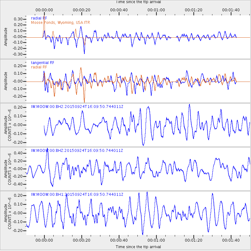
Signal To Noise
| Channel | StoN | STA | LTA |
| IW:MOOW:00:BHZ:20150924T16:09:50.744011Z | 2.7629013 | 2.9225995E-7 | 1.05780096E-7 |
| IW:MOOW:00:BH1:20150924T16:09:50.744011Z | 1.1514057 | 9.7860905E-8 | 8.499254E-8 |
| IW:MOOW:00:BH2:20150924T16:09:50.744011Z | 0.8634465 | 5.705487E-8 | 6.6078066E-8 |
| Arrivals |
| Ps | |
| PpPs | |
| PsPs/PpSs | |


