You are here: Home > Network List > MM - Myanmar National Seismic Network Stations List
> Station HKA Haka, Chin, Myanmar > Earthquake Result Viewer
HKA Haka, Chin, Myanmar - Earthquake Result Viewer
| Earthquake location: |
Mindanao, Philippines |
| Earthquake latitude/longitude: |
6.6/126.5 |
| Earthquake time(UTC): |
2016/09/23 (267) 22:53:10 GMT |
| Earthquake Depth: |
62 km |
| Earthquake Magnitude: |
6.3 MO |
| Earthquake Catalog/Contributor: |
NEIC PDE/NEIC ALERT |
|
| Network: |
MM Myanmar National Seismic Network |
| Station: |
HKA Haka, Chin, Myanmar |
| Lat/Lon: |
22.64 N/93.60 E |
| Elevation: |
1733 m |
|
| Distance: |
35.5 deg |
| Az: |
300.214 deg |
| Baz: |
111.67 deg |
| Ray Param: |
0.077024855 |
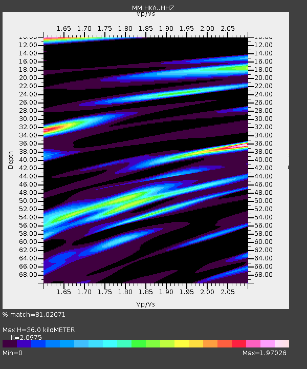
| Estimated Moho Depth: |
36.0 km |
| Estimated Crust Vp/Vs: |
2.10 |
| Assumed Crust Vp: |
6.552 km/s |
| Estimated Crust Vs: |
3.124 km/s |
| Estimated Crust Poisson's Ratio: |
0.35 |
|
| Radial Match: |
81.02071 % |
| Radial Bump: |
400 |
| Transverse Match: |
56.80256 % |
| Transverse Bump: |
400 |
| SOD ConfigId: |
11737051 |
| Insert Time: |
2019-04-25 14:18:48.677 +0000 |
| GWidth: |
2.5 |
| Max Bumps: |
400 |
| Tol: |
0.001 |
|

Signal To Noise
| Channel | StoN | STA | LTA |
| MM:HKA: :HHZ:20160923T22:59:30.437988Z | 3.4192069 | 3.2425282E-7 | 9.4832764E-8 |
| MM:HKA: :HHN:20160923T22:59:30.437988Z | 1.9730242 | 1.70473E-7 | 8.6401876E-8 |
| MM:HKA: :HHE:20160923T22:59:30.437988Z | 1.5965865 | 1.6784371E-7 | 1.051266E-7 |
| Arrivals |
| Ps | 6.4 SECOND |
| PpPs | 16 SECOND |
| PsPs/PpSs | 22 SECOND |


