You are here: Home > Network List > TA - USArray Transportable Network (new EarthScope stations) Stations List
> Station D23K Nanushuk River, AK USA > Earthquake Result Viewer
D23K Nanushuk River, AK USA - Earthquake Result Viewer

| Earthquake location: |
Mindanao, Philippines |
| Earthquake latitude/longitude: |
6.6/126.5 |
| Earthquake time(UTC): |
2016/09/23 (267) 22:53:10 GMT |
| Earthquake Depth: |
62 km |
| Earthquake Magnitude: |
6.3 MO |
| Earthquake Catalog/Contributor: |
NEIC PDE/NEIC ALERT |
|
| Network: |
TA USArray Transportable Network (new EarthScope stations) |
| Station: |
D23K Nanushuk River, AK USA |
| Lat/Lon: |
68.97 N/150.68 W |
| Elevation: |
406 m |
|
| Distance: |
81.3 deg |
| Az: |
21.245 deg |
| Baz: |
265.676 deg |
| Ray Param: |
0.04754005 |
| Estimated Moho Depth: |
43.5 km |
| Estimated Crust Vp/Vs: |
1.80 |
| Assumed Crust Vp: |
6.221 km/s |
| Estimated Crust Vs: |
3.466 km/s |
| Estimated Crust Poisson's Ratio: |
0.27 |
|
| Radial Match: |
89.338104 % |
| Radial Bump: |
400 |
| Transverse Match: |
83.617935 % |
| Transverse Bump: |
400 |
| SOD ConfigId: |
11737051 |
| Insert Time: |
2019-04-25 14:19:41.618 +0000 |
| GWidth: |
2.5 |
| Max Bumps: |
400 |
| Tol: |
0.001 |
|
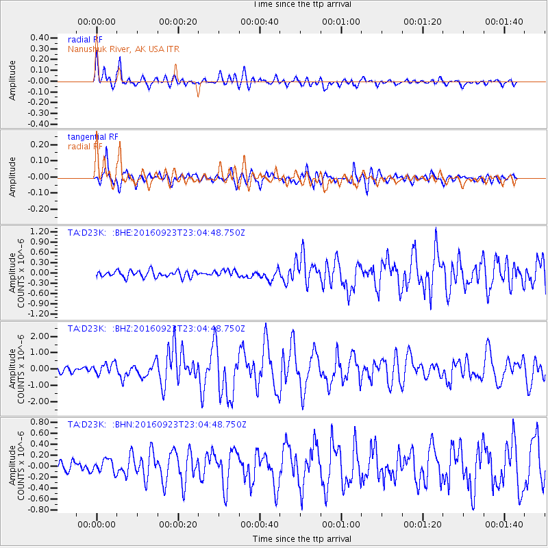
Signal To Noise
| Channel | StoN | STA | LTA |
| TA:D23K: :BHZ:20160923T23:04:48.750Z | 2.293104 | 3.4197024E-7 | 1.4912985E-7 |
| TA:D23K: :BHN:20160923T23:04:48.750Z | 1.1282872 | 1.18795946E-7 | 1.05288755E-7 |
| TA:D23K: :BHE:20160923T23:04:48.750Z | 1.010153 | 9.6388234E-8 | 9.541944E-8 |
| Arrivals |
| Ps | 5.7 SECOND |
| PpPs | 19 SECOND |
| PsPs/PpSs | 25 SECOND |


