You are here: Home > Network List > TA - USArray Transportable Network (new EarthScope stations) Stations List
> Station E23K Chandalar, AK, USA > Earthquake Result Viewer
E23K Chandalar, AK, USA - Earthquake Result Viewer
| Earthquake location: |
Mindanao, Philippines |
| Earthquake latitude/longitude: |
6.6/126.5 |
| Earthquake time(UTC): |
2016/09/23 (267) 22:53:10 GMT |
| Earthquake Depth: |
62 km |
| Earthquake Magnitude: |
6.3 MO |
| Earthquake Catalog/Contributor: |
NEIC PDE/NEIC ALERT |
|
| Network: |
TA USArray Transportable Network (new EarthScope stations) |
| Station: |
E23K Chandalar, AK, USA |
| Lat/Lon: |
68.06 N/149.62 W |
| Elevation: |
1084 m |
|
| Distance: |
81.7 deg |
| Az: |
22.191 deg |
| Baz: |
266.806 deg |
| Ray Param: |
0.047307726 |
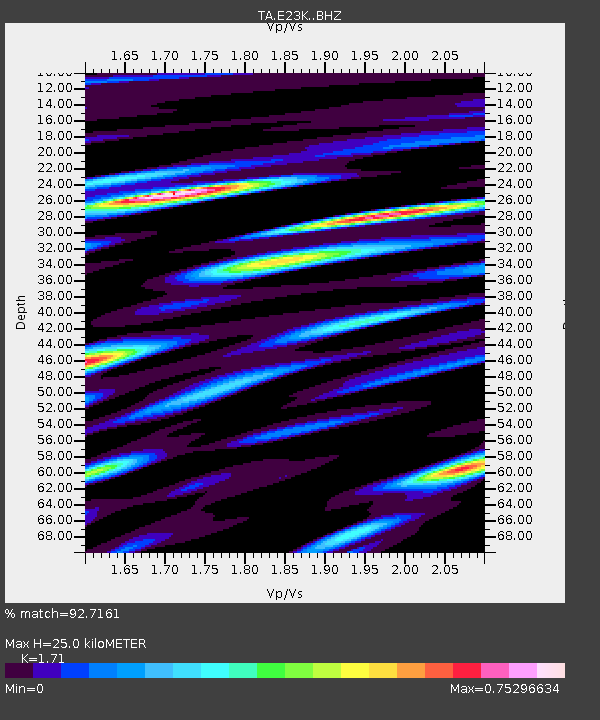
| Estimated Moho Depth: |
25.0 km |
| Estimated Crust Vp/Vs: |
1.71 |
| Assumed Crust Vp: |
6.316 km/s |
| Estimated Crust Vs: |
3.694 km/s |
| Estimated Crust Poisson's Ratio: |
0.24 |
|
| Radial Match: |
92.7161 % |
| Radial Bump: |
400 |
| Transverse Match: |
88.42601 % |
| Transverse Bump: |
400 |
| SOD ConfigId: |
11737051 |
| Insert Time: |
2019-04-25 14:19:43.518 +0000 |
| GWidth: |
2.5 |
| Max Bumps: |
400 |
| Tol: |
0.001 |
|

Signal To Noise
| Channel | StoN | STA | LTA |
| TA:E23K: :BHZ:20160923T23:04:50.474976Z | 3.2604542 | 2.4602835E-7 | 7.54583E-8 |
| TA:E23K: :BHN:20160923T23:04:50.474976Z | 0.8174762 | 6.851003E-8 | 8.380675E-8 |
| TA:E23K: :BHE:20160923T23:04:50.474976Z | 1.0351313 | 9.7442154E-8 | 9.413506E-8 |
| Arrivals |
| Ps | 2.9 SECOND |
| PpPs | 10 SECOND |
| PsPs/PpSs | 13 SECOND |


