You are here: Home > Network List > TA - USArray Transportable Network (new EarthScope stations) Stations List
> Station F22K John River, AK, USA > Earthquake Result Viewer
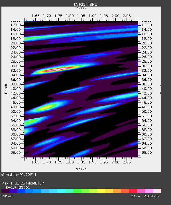
F22K John River, AK, USA - Earthquake Result Viewer
| Earthquake location: |
Mindanao, Philippines |
| Earthquake latitude/longitude: |
6.6/126.5 |
| Earthquake time(UTC): |
2016/09/23 (267) 22:53:10 GMT |
| Earthquake Depth: |
62 km |
| Earthquake Magnitude: |
6.3 MO |
| Earthquake Catalog/Contributor: |
NEIC PDE/NEIC ALERT |
|
| Network: |
TA USArray Transportable Network (new EarthScope stations) |
| Station: |
F22K John River, AK, USA |
| Lat/Lon: |
67.51 N/152.18 W |
| Elevation: |
546 m |
|
| Distance: |
80.6 deg |
| Az: |
22.674 deg |
| Baz: |
264.51 deg |
| Ray Param: |
0.04801482 |
| Estimated Moho Depth: |
31.25 km |
| Estimated Crust Vp/Vs: |
1.74 |
| Assumed Crust Vp: |
6.455 km/s |
| Estimated Crust Vs: |
3.705 km/s |
| Estimated Crust Poisson's Ratio: |
0.25 |
|
| Radial Match: |
91.70811 % |
| Radial Bump: |
400 |
| Transverse Match: |
84.34215 % |
| Transverse Bump: |
400 |
| SOD ConfigId: |
11737051 |
| Insert Time: |
2019-04-25 14:19:47.594 +0000 |
| GWidth: |
2.5 |
| Max Bumps: |
400 |
| Tol: |
0.001 |
|

Signal To Noise
| Channel | StoN | STA | LTA |
| TA:F22K: :BHZ:20160923T23:04:45.125Z | 2.712449 | 1.8894626E-7 | 6.965892E-8 |
| TA:F22K: :BHN:20160923T23:04:45.125Z | 0.8174445 | 5.6547208E-8 | 6.917559E-8 |
| TA:F22K: :BHE:20160923T23:04:45.125Z | 0.83577406 | 6.2287675E-8 | 7.452693E-8 |
| Arrivals |
| Ps | 3.7 SECOND |
| PpPs | 13 SECOND |
| PsPs/PpSs | 17 SECOND |


