You are here: Home > Network List > TA - USArray Transportable Network (new EarthScope stations) Stations List
> Station F26K Sheenjek River, AK, USA > Earthquake Result Viewer
F26K Sheenjek River, AK, USA - Earthquake Result Viewer

| Earthquake location: |
Mindanao, Philippines |
| Earthquake latitude/longitude: |
6.6/126.5 |
| Earthquake time(UTC): |
2016/09/23 (267) 22:53:10 GMT |
| Earthquake Depth: |
62 km |
| Earthquake Magnitude: |
6.3 MO |
| Earthquake Catalog/Contributor: |
NEIC PDE/NEIC ALERT |
|
| Network: |
TA USArray Transportable Network (new EarthScope stations) |
| Station: |
F26K Sheenjek River, AK, USA |
| Lat/Lon: |
67.69 N/144.15 W |
| Elevation: |
683 m |
|
| Distance: |
83.7 deg |
| Az: |
22.582 deg |
| Baz: |
271.919 deg |
| Ray Param: |
0.045861717 |
| Estimated Moho Depth: |
42.75 km |
| Estimated Crust Vp/Vs: |
1.61 |
| Assumed Crust Vp: |
6.522 km/s |
| Estimated Crust Vs: |
4.063 km/s |
| Estimated Crust Poisson's Ratio: |
0.18 |
|
| Radial Match: |
91.40434 % |
| Radial Bump: |
400 |
| Transverse Match: |
78.33968 % |
| Transverse Bump: |
400 |
| SOD ConfigId: |
11737051 |
| Insert Time: |
2019-04-25 14:19:47.703 +0000 |
| GWidth: |
2.5 |
| Max Bumps: |
400 |
| Tol: |
0.001 |
|
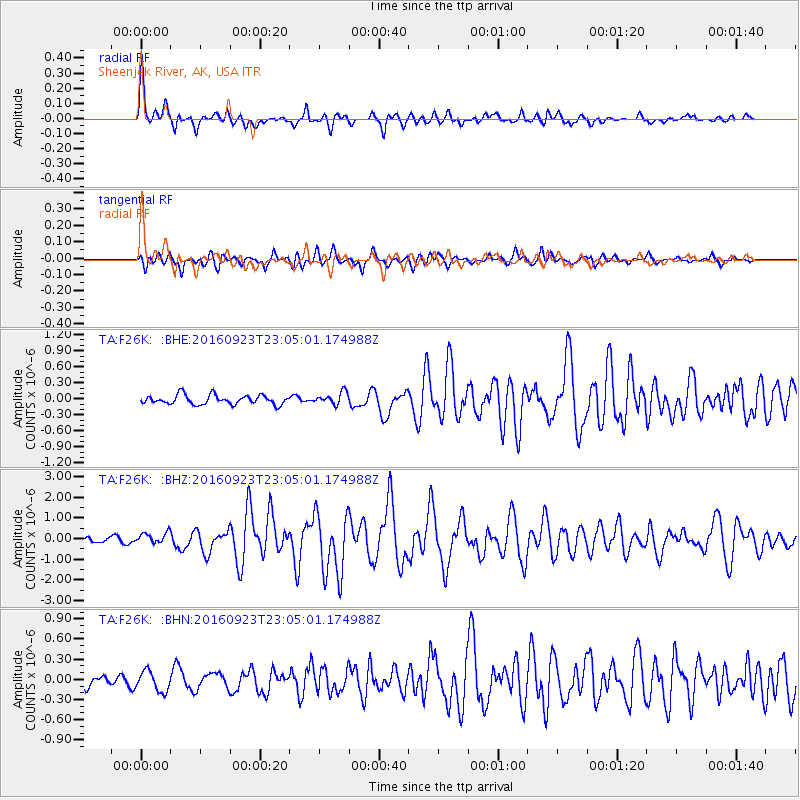
Signal To Noise
| Channel | StoN | STA | LTA |
| TA:F26K: :BHZ:20160923T23:05:01.174988Z | 2.994565 | 2.6640836E-7 | 8.8963965E-8 |
| TA:F26K: :BHN:20160923T23:05:01.174988Z | 1.2846104 | 1.5026731E-7 | 1.1697501E-7 |
| TA:F26K: :BHE:20160923T23:05:01.174988Z | 1.3358097 | 1.146276E-7 | 8.581133E-8 |
| Arrivals |
| Ps | 4.1 SECOND |
| PpPs | 17 SECOND |
| PsPs/PpSs | 21 SECOND |


