You are here: Home > Network List > TA - USArray Transportable Network (new EarthScope stations) Stations List
> Station G21K Allakaket, AK, USA > Earthquake Result Viewer
G21K Allakaket, AK, USA - Earthquake Result Viewer
| Earthquake location: |
Mindanao, Philippines |
| Earthquake latitude/longitude: |
6.6/126.5 |
| Earthquake time(UTC): |
2016/09/23 (267) 22:53:10 GMT |
| Earthquake Depth: |
62 km |
| Earthquake Magnitude: |
6.3 MO |
| Earthquake Catalog/Contributor: |
NEIC PDE/NEIC ALERT |
|
| Network: |
TA USArray Transportable Network (new EarthScope stations) |
| Station: |
G21K Allakaket, AK, USA |
| Lat/Lon: |
66.52 N/153.51 W |
| Elevation: |
446 m |
|
| Distance: |
80.0 deg |
| Az: |
23.624 deg |
| Baz: |
263.449 deg |
| Ray Param: |
0.04843695 |
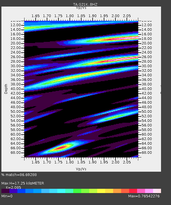
| Estimated Moho Depth: |
17.25 km |
| Estimated Crust Vp/Vs: |
2.09 |
| Assumed Crust Vp: |
6.455 km/s |
| Estimated Crust Vs: |
3.096 km/s |
| Estimated Crust Poisson's Ratio: |
0.35 |
|
| Radial Match: |
86.69288 % |
| Radial Bump: |
400 |
| Transverse Match: |
81.85388 % |
| Transverse Bump: |
400 |
| SOD ConfigId: |
11737051 |
| Insert Time: |
2019-04-25 14:19:48.199 +0000 |
| GWidth: |
2.5 |
| Max Bumps: |
400 |
| Tol: |
0.001 |
|
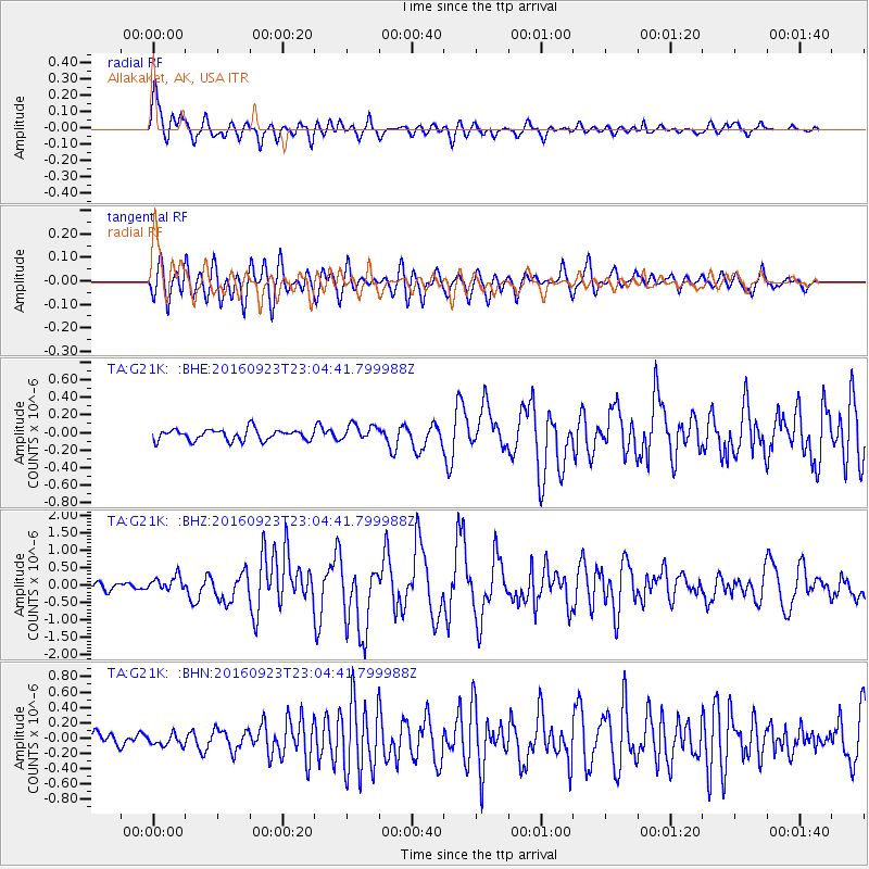
Signal To Noise
| Channel | StoN | STA | LTA |
| TA:G21K: :BHZ:20160923T23:04:41.799988Z | 2.4871378 | 2.1157429E-7 | 8.506738E-8 |
| TA:G21K: :BHN:20160923T23:04:41.799988Z | 0.74785936 | 6.971544E-8 | 9.321999E-8 |
| TA:G21K: :BHE:20160923T23:04:41.799988Z | 1.4400921 | 9.181148E-8 | 6.3753895E-8 |
| Arrivals |
| Ps | 3.0 SECOND |
| PpPs | 8.0 SECOND |
| PsPs/PpSs | 11 SECOND |


