You are here: Home > Network List > TA - USArray Transportable Network (new EarthScope stations) Stations List
> Station K20K Telida, AK, USA > Earthquake Result Viewer
K20K Telida, AK, USA - Earthquake Result Viewer
| Earthquake location: |
Mindanao, Philippines |
| Earthquake latitude/longitude: |
6.6/126.5 |
| Earthquake time(UTC): |
2016/09/23 (267) 22:53:10 GMT |
| Earthquake Depth: |
62 km |
| Earthquake Magnitude: |
6.3 MO |
| Earthquake Catalog/Contributor: |
NEIC PDE/NEIC ALERT |
|
| Network: |
TA USArray Transportable Network (new EarthScope stations) |
| Station: |
K20K Telida, AK, USA |
| Lat/Lon: |
63.36 N/154.07 W |
| Elevation: |
548 m |
|
| Distance: |
79.4 deg |
| Az: |
26.799 deg |
| Baz: |
263.505 deg |
| Ray Param: |
0.048845924 |
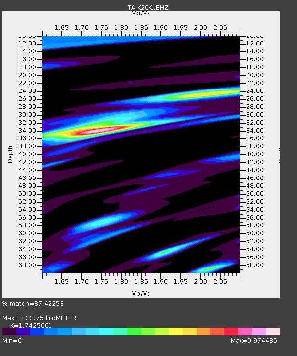
| Estimated Moho Depth: |
33.75 km |
| Estimated Crust Vp/Vs: |
1.74 |
| Assumed Crust Vp: |
6.438 km/s |
| Estimated Crust Vs: |
3.695 km/s |
| Estimated Crust Poisson's Ratio: |
0.25 |
|
| Radial Match: |
87.42253 % |
| Radial Bump: |
338 |
| Transverse Match: |
80.03441 % |
| Transverse Bump: |
356 |
| SOD ConfigId: |
11737051 |
| Insert Time: |
2019-04-25 14:20:00.956 +0000 |
| GWidth: |
2.5 |
| Max Bumps: |
400 |
| Tol: |
0.001 |
|

Signal To Noise
| Channel | StoN | STA | LTA |
| TA:K20K: :BHZ:20160923T23:04:38.575012Z | 3.2358737 | 2.900713E-7 | 8.964234E-8 |
| TA:K20K: :BHN:20160923T23:04:38.575012Z | 0.8577729 | 9.089642E-8 | 1.0596793E-7 |
| TA:K20K: :BHE:20160923T23:04:38.575012Z | 1.1214539 | 1.3890262E-7 | 1.2385941E-7 |
| Arrivals |
| Ps | 4.0 SECOND |
| PpPs | 14 SECOND |
| PsPs/PpSs | 18 SECOND |


