You are here: Home > Network List > US - United States National Seismic Network Stations List
> Station HAWA Hanford, Washington, USA > Earthquake Result Viewer
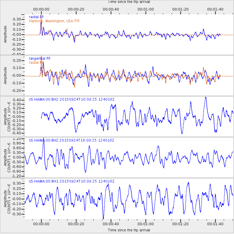
HAWA Hanford, Washington, USA - Earthquake Result Viewer
*The percent match for this event was below the threshold and hence no stack was calculated.
| Earthquake location: |
Solomon Islands |
| Earthquake latitude/longitude: |
-10.1/160.5 |
| Earthquake time(UTC): |
2015/09/24 (267) 15:56:57 GMT |
| Earthquake Depth: |
23 km |
| Earthquake Magnitude: |
6.0 MB |
| Earthquake Catalog/Contributor: |
NEIC PDE/NEIC COMCAT |
|
| Network: |
US United States National Seismic Network |
| Station: |
HAWA Hanford, Washington, USA |
| Lat/Lon: |
46.39 N/119.53 W |
| Elevation: |
364 m |
|
| Distance: |
90.4 deg |
| Az: |
42.968 deg |
| Baz: |
255.826 deg |
| Ray Param: |
$rayparam |
*The percent match for this event was below the threshold and hence was not used in the summary stack. |
|
| Radial Match: |
62.569885 % |
| Radial Bump: |
400 |
| Transverse Match: |
58.552902 % |
| Transverse Bump: |
385 |
| SOD ConfigId: |
1156111 |
| Insert Time: |
2015-10-08 16:31:44.383 +0000 |
| GWidth: |
2.5 |
| Max Bumps: |
400 |
| Tol: |
0.001 |
|
Signal To Noise
| Channel | StoN | STA | LTA |
| US:HAWA:00:BHZ:20150924T16:09:25.124016Z | 3.1233232 | 5.1185486E-7 | 1.6388148E-7 |
| US:HAWA:00:BH1:20150924T16:09:25.124016Z | 0.6155213 | 6.8009996E-8 | 1.10491705E-7 |
| US:HAWA:00:BH2:20150924T16:09:25.124016Z | 0.9397832 | 1.17126476E-7 | 1.2463138E-7 |
| Arrivals |
| Ps | |
| PpPs | |
| PsPs/PpSs | |


