You are here: Home > Network List > US - United States National Seismic Network Stations List
> Station LAO LASA Array, Montana, USA > Earthquake Result Viewer
LAO LASA Array, Montana, USA - Earthquake Result Viewer
| Earthquake location: |
Southern Greece |
| Earthquake latitude/longitude: |
38.0/21.5 |
| Earthquake time(UTC): |
2008/06/08 (160) 12:25:29 GMT |
| Earthquake Depth: |
16 km |
| Earthquake Magnitude: |
6.2 MB, 6.3 MS, 6.3 MW, 6.3 MW |
| Earthquake Catalog/Contributor: |
WHDF/NEIC |
|
| Network: |
US United States National Seismic Network |
| Station: |
LAO LASA Array, Montana, USA |
| Lat/Lon: |
46.69 N/106.22 W |
| Elevation: |
902 m |
|
| Distance: |
83.6 deg |
| Az: |
326.789 deg |
| Baz: |
38.968 deg |
| Ray Param: |
0.04605206 |
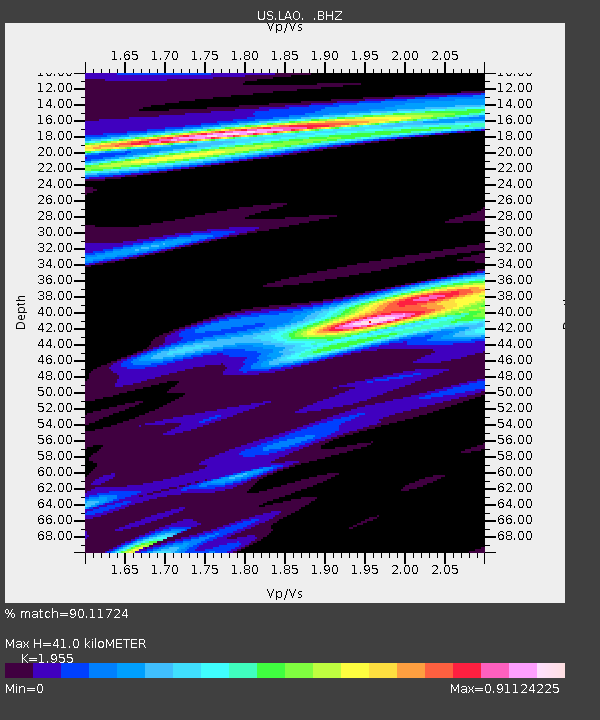
| Estimated Moho Depth: |
41.0 km |
| Estimated Crust Vp/Vs: |
1.96 |
| Assumed Crust Vp: |
6.438 km/s |
| Estimated Crust Vs: |
3.293 km/s |
| Estimated Crust Poisson's Ratio: |
0.32 |
|
| Radial Match: |
90.11724 % |
| Radial Bump: |
400 |
| Transverse Match: |
79.50288 % |
| Transverse Bump: |
400 |
| SOD ConfigId: |
2504 |
| Insert Time: |
2010-03-05 07:10:46.764 +0000 |
| GWidth: |
2.5 |
| Max Bumps: |
400 |
| Tol: |
0.001 |
|

Signal To Noise
| Channel | StoN | STA | LTA |
| US:LAO: :BHZ:20080608T12:37:25.727029Z | 3.042714 | 3.314822E-7 | 1.08942935E-7 |
| US:LAO: :BHN:20080608T12:37:25.727029Z | 0.8258027 | 1.0584856E-7 | 1.2817658E-7 |
| US:LAO: :BHE:20080608T12:37:25.727029Z | 0.6820948 | 9.114814E-8 | 1.3362973E-7 |
| Arrivals |
| Ps | 6.2 SECOND |
| PpPs | 18 SECOND |
| PsPs/PpSs | 25 SECOND |


