You are here: Home > Network List > N4 - Central and EAstern US Network Stations List
> Station T60A Surry, VA, USA > Earthquake Result Viewer
T60A Surry, VA, USA - Earthquake Result Viewer
| Earthquake location: |
Romania |
| Earthquake latitude/longitude: |
45.7/26.6 |
| Earthquake time(UTC): |
2016/09/23 (267) 23:11:20 GMT |
| Earthquake Depth: |
88 km |
| Earthquake Magnitude: |
5.6 MO |
| Earthquake Catalog/Contributor: |
NEIC PDE/NEIC ALERT |
|
| Network: |
N4 Central and EAstern US Network |
| Station: |
T60A Surry, VA, USA |
| Lat/Lon: |
37.14 N/76.73 W |
| Elevation: |
11 m |
|
| Distance: |
72.6 deg |
| Az: |
305.42 deg |
| Baz: |
45.593 deg |
| Ray Param: |
0.053373177 |
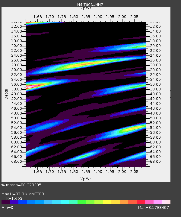
| Estimated Moho Depth: |
37.0 km |
| Estimated Crust Vp/Vs: |
1.61 |
| Assumed Crust Vp: |
6.565 km/s |
| Estimated Crust Vs: |
4.09 km/s |
| Estimated Crust Poisson's Ratio: |
0.18 |
|
| Radial Match: |
80.273285 % |
| Radial Bump: |
280 |
| Transverse Match: |
51.667595 % |
| Transverse Bump: |
391 |
| SOD ConfigId: |
11737051 |
| Insert Time: |
2019-04-25 14:27:59.409 +0000 |
| GWidth: |
2.5 |
| Max Bumps: |
400 |
| Tol: |
0.001 |
|

Signal To Noise
| Channel | StoN | STA | LTA |
| N4:T60A: :HHZ:20160923T23:22:07.000Z | 3.411095 | 4.3400757E-7 | 1.272341E-7 |
| N4:T60A: :HHN:20160923T23:22:07.000Z | 0.99159086 | 3.5025639E-7 | 3.5322674E-7 |
| N4:T60A: :HHE:20160923T23:22:07.000Z | 1.991718 | 4.3542587E-7 | 2.1861823E-7 |
| Arrivals |
| Ps | 3.5 SECOND |
| PpPs | 14 SECOND |
| PsPs/PpSs | 18 SECOND |


