You are here: Home > Network List > TA - USArray Transportable Network (new EarthScope stations) Stations List
> Station R33M Jennings River, BC, CAN > Earthquake Result Viewer
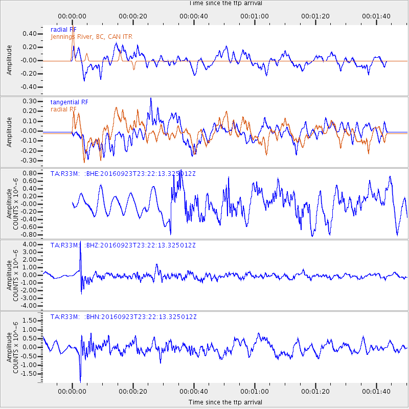
R33M Jennings River, BC, CAN - Earthquake Result Viewer
*The percent match for this event was below the threshold and hence no stack was calculated.
| Earthquake location: |
Romania |
| Earthquake latitude/longitude: |
45.7/26.6 |
| Earthquake time(UTC): |
2016/09/23 (267) 23:11:20 GMT |
| Earthquake Depth: |
88 km |
| Earthquake Magnitude: |
5.6 MO |
| Earthquake Catalog/Contributor: |
NEIC PDE/NEIC ALERT |
|
| Network: |
TA USArray Transportable Network (new EarthScope stations) |
| Station: |
R33M Jennings River, BC, CAN |
| Lat/Lon: |
59.39 N/130.97 W |
| Elevation: |
1437 m |
|
| Distance: |
73.6 deg |
| Az: |
348.272 deg |
| Baz: |
16.158 deg |
| Ray Param: |
$rayparam |
*The percent match for this event was below the threshold and hence was not used in the summary stack. |
|
| Radial Match: |
64.973404 % |
| Radial Bump: |
400 |
| Transverse Match: |
64.48764 % |
| Transverse Bump: |
400 |
| SOD ConfigId: |
11737051 |
| Insert Time: |
2019-04-25 14:31:12.382 +0000 |
| GWidth: |
2.5 |
| Max Bumps: |
400 |
| Tol: |
0.001 |
|
Signal To Noise
| Channel | StoN | STA | LTA |
| TA:R33M: :BHZ:20160923T23:22:13.325012Z | 3.5969815 | 1.1105456E-6 | 3.0874375E-7 |
| TA:R33M: :BHN:20160923T23:22:13.325012Z | 1.5482969 | 4.9100197E-7 | 3.171239E-7 |
| TA:R33M: :BHE:20160923T23:22:13.325012Z | 2.0680842 | 4.197482E-7 | 2.0296476E-7 |
| Arrivals |
| Ps | |
| PpPs | |
| PsPs/PpSs | |


