You are here: Home > Network List > AU - Australian Seismological Centre Stations List
> Station CTA Charters Towers, Queensland > Earthquake Result Viewer
CTA Charters Towers, Queensland - Earthquake Result Viewer
| Earthquake location: |
South Of Kermadec Islands |
| Earthquake latitude/longitude: |
-32.6/-177.6 |
| Earthquake time(UTC): |
2016/09/24 (268) 04:02:13 GMT |
| Earthquake Depth: |
10 km |
| Earthquake Magnitude: |
5.8 MO |
| Earthquake Catalog/Contributor: |
NEIC PDE/NEIC ALERT |
|
| Network: |
AU Australian Seismological Centre |
| Station: |
CTA Charters Towers, Queensland |
| Lat/Lon: |
20.09 S/146.25 E |
| Elevation: |
426 m |
|
| Distance: |
34.6 deg |
| Az: |
281.987 deg |
| Baz: |
118.484 deg |
| Ray Param: |
0.07767509 |
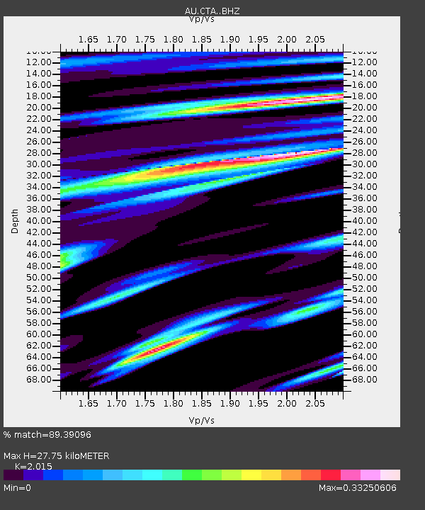
| Estimated Moho Depth: |
27.75 km |
| Estimated Crust Vp/Vs: |
2.02 |
| Assumed Crust Vp: |
6.522 km/s |
| Estimated Crust Vs: |
3.237 km/s |
| Estimated Crust Poisson's Ratio: |
0.34 |
|
| Radial Match: |
89.39096 % |
| Radial Bump: |
273 |
| Transverse Match: |
49.516094 % |
| Transverse Bump: |
400 |
| SOD ConfigId: |
11737051 |
| Insert Time: |
2019-04-25 14:34:26.607 +0000 |
| GWidth: |
2.5 |
| Max Bumps: |
400 |
| Tol: |
0.001 |
|

Signal To Noise
| Channel | StoN | STA | LTA |
| AU:CTA: :BHZ:20160924T04:08:30.500Z | 8.48501 | 1.0912981E-6 | 1.2861483E-7 |
| AU:CTA: :BHN:20160924T04:08:30.500Z | 2.4116144 | 3.3488556E-7 | 1.3886363E-7 |
| AU:CTA: :BHE:20160924T04:08:30.500Z | 3.8691514 | 6.1237483E-7 | 1.582711E-7 |
| Arrivals |
| Ps | 4.6 SECOND |
| PpPs | 12 SECOND |
| PsPs/PpSs | 17 SECOND |


