You are here: Home > Network List > US - United States National Seismic Network Stations List
> Station LAO LASA Array, Montana, USA > Earthquake Result Viewer
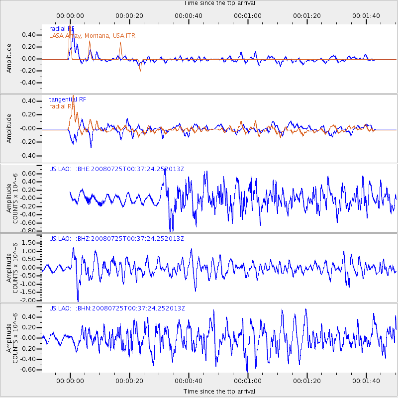
LAO LASA Array, Montana, USA - Earthquake Result Viewer
*The percent match for this event was below the threshold and hence no stack was calculated.
| Earthquake location: |
Rat Islands, Aleutian Islands |
| Earthquake latitude/longitude: |
51.3/179.0 |
| Earthquake time(UTC): |
2008/07/25 (207) 00:29:22 GMT |
| Earthquake Depth: |
21 km |
| Earthquake Magnitude: |
5.7 MB, 5.5 MS, 5.9 MW, 5.9 MW |
| Earthquake Catalog/Contributor: |
WHDF/NEIC |
|
| Network: |
US United States National Seismic Network |
| Station: |
LAO LASA Array, Montana, USA |
| Lat/Lon: |
46.69 N/106.22 W |
| Elevation: |
902 m |
|
| Distance: |
47.3 deg |
| Az: |
64.625 deg |
| Baz: |
304.476 deg |
| Ray Param: |
$rayparam |
*The percent match for this event was below the threshold and hence was not used in the summary stack. |
|
| Radial Match: |
76.98198 % |
| Radial Bump: |
400 |
| Transverse Match: |
75.92761 % |
| Transverse Bump: |
400 |
| SOD ConfigId: |
2504 |
| Insert Time: |
2010-03-05 07:12:43.812 +0000 |
| GWidth: |
2.5 |
| Max Bumps: |
400 |
| Tol: |
0.001 |
|
Signal To Noise
| Channel | StoN | STA | LTA |
| US:LAO: :BHZ:20080725T00:37:24.252013Z | 7.3795147 | 7.92208E-7 | 1.0735232E-7 |
| US:LAO: :BHN:20080725T00:37:24.252013Z | 1.3565176 | 1.1850426E-7 | 8.7359176E-8 |
| US:LAO: :BHE:20080725T00:37:24.252013Z | 4.2852407 | 4.0120574E-7 | 9.362502E-8 |
| Arrivals |
| Ps | |
| PpPs | |
| PsPs/PpSs | |


