You are here: Home > Network List > KZ - Kazakhstan Network Stations List
> Station MKAR Makanchi array,MK31, Kazakhstan > Earthquake Result Viewer
MKAR Makanchi array,MK31, Kazakhstan - Earthquake Result Viewer
| Earthquake location: |
Irian Jaya Region, Indonesia |
| Earthquake latitude/longitude: |
-1.9/140.6 |
| Earthquake time(UTC): |
2016/09/24 (268) 11:04:30 GMT |
| Earthquake Depth: |
10 km |
| Earthquake Magnitude: |
5.6 MB |
| Earthquake Catalog/Contributor: |
NEIC PDE/NEIC ALERT |
|
| Network: |
KZ Kazakhstan Network |
| Station: |
MKAR Makanchi array,MK31, Kazakhstan |
| Lat/Lon: |
46.79 N/82.29 E |
| Elevation: |
615 m |
|
| Distance: |
70.4 deg |
| Az: |
321.622 deg |
| Baz: |
115.431 deg |
| Ray Param: |
0.055032764 |
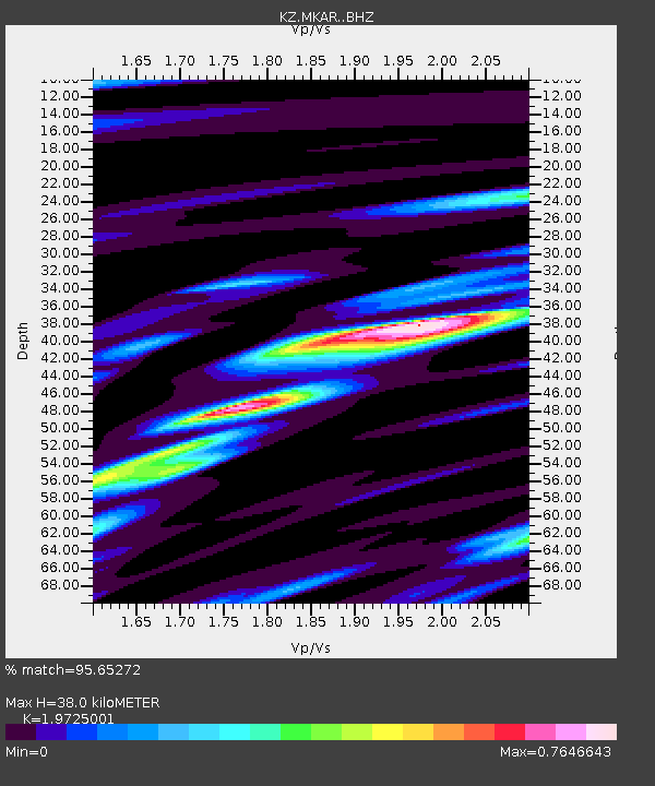
| Estimated Moho Depth: |
38.0 km |
| Estimated Crust Vp/Vs: |
1.97 |
| Assumed Crust Vp: |
6.688 km/s |
| Estimated Crust Vs: |
3.391 km/s |
| Estimated Crust Poisson's Ratio: |
0.33 |
|
| Radial Match: |
95.65272 % |
| Radial Bump: |
400 |
| Transverse Match: |
79.55689 % |
| Transverse Bump: |
400 |
| SOD ConfigId: |
11737051 |
| Insert Time: |
2019-04-25 14:42:27.471 +0000 |
| GWidth: |
2.5 |
| Max Bumps: |
400 |
| Tol: |
0.001 |
|

Signal To Noise
| Channel | StoN | STA | LTA |
| KZ:MKAR: :BHZ:20160924T11:15:12.500977Z | 20.147055 | 1.436717E-6 | 7.131151E-8 |
| KZ:MKAR: :BHN:20160924T11:15:12.500977Z | 4.682287 | 3.245375E-7 | 6.9311746E-8 |
| KZ:MKAR: :BHE:20160924T11:15:12.500977Z | 6.8374023 | 3.7662494E-7 | 5.5083042E-8 |
| Arrivals |
| Ps | 5.7 SECOND |
| PpPs | 16 SECOND |
| PsPs/PpSs | 22 SECOND |


