You are here: Home > Network List > TA - USArray Transportable Network (new EarthScope stations) Stations List
> Station D23K Nanushuk River, AK USA > Earthquake Result Viewer
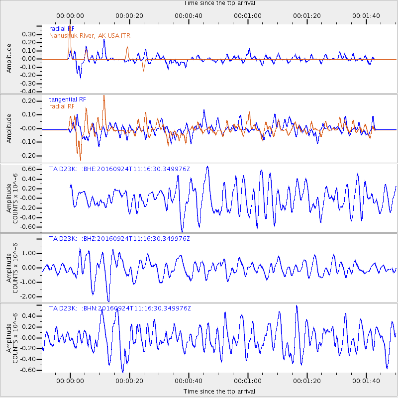
D23K Nanushuk River, AK USA - Earthquake Result Viewer
*The percent match for this event was below the threshold and hence no stack was calculated.
| Earthquake location: |
Irian Jaya Region, Indonesia |
| Earthquake latitude/longitude: |
-1.9/140.6 |
| Earthquake time(UTC): |
2016/09/24 (268) 11:04:30 GMT |
| Earthquake Depth: |
10 km |
| Earthquake Magnitude: |
5.6 MB |
| Earthquake Catalog/Contributor: |
NEIC PDE/NEIC ALERT |
|
| Network: |
TA USArray Transportable Network (new EarthScope stations) |
| Station: |
D23K Nanushuk River, AK USA |
| Lat/Lon: |
68.97 N/150.68 W |
| Elevation: |
406 m |
|
| Distance: |
84.3 deg |
| Az: |
19.759 deg |
| Baz: |
249.363 deg |
| Ray Param: |
$rayparam |
*The percent match for this event was below the threshold and hence was not used in the summary stack. |
|
| Radial Match: |
66.10939 % |
| Radial Bump: |
400 |
| Transverse Match: |
70.57658 % |
| Transverse Bump: |
400 |
| SOD ConfigId: |
11737051 |
| Insert Time: |
2019-04-25 14:43:26.351 +0000 |
| GWidth: |
2.5 |
| Max Bumps: |
400 |
| Tol: |
0.001 |
|
Signal To Noise
| Channel | StoN | STA | LTA |
| TA:D23K: :BHZ:20160924T11:16:30.349976Z | 2.1150286 | 5.002481E-7 | 2.3652073E-7 |
| TA:D23K: :BHN:20160924T11:16:30.349976Z | 0.67047286 | 9.6900706E-8 | 1.4452591E-7 |
| TA:D23K: :BHE:20160924T11:16:30.349976Z | 0.97216046 | 1.3236937E-7 | 1.3616E-7 |
| Arrivals |
| Ps | |
| PpPs | |
| PsPs/PpSs | |


