You are here: Home > Network List > TJ - Tajikistan National Seismic Network Stations List
> Station IGRN Igron, Tajikistan > Earthquake Result Viewer
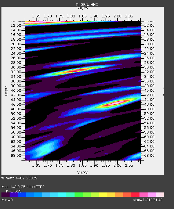
IGRN Igron, Tajikistan - Earthquake Result Viewer
| Earthquake location: |
Irian Jaya Region, Indonesia |
| Earthquake latitude/longitude: |
-1.9/140.6 |
| Earthquake time(UTC): |
2016/09/24 (268) 11:04:30 GMT |
| Earthquake Depth: |
10 km |
| Earthquake Magnitude: |
5.6 MB |
| Earthquake Catalog/Contributor: |
NEIC PDE/NEIC ALERT |
|
| Network: |
TJ Tajikistan National Seismic Network |
| Station: |
IGRN Igron, Tajikistan |
| Lat/Lon: |
38.22 N/69.33 E |
| Elevation: |
1284 m |
|
| Distance: |
76.6 deg |
| Az: |
309.923 deg |
| Baz: |
103.317 deg |
| Ray Param: |
0.050885092 |
| Estimated Moho Depth: |
10.25 km |
| Estimated Crust Vp/Vs: |
1.66 |
| Assumed Crust Vp: |
6.483 km/s |
| Estimated Crust Vs: |
3.893 km/s |
| Estimated Crust Poisson's Ratio: |
0.22 |
|
| Radial Match: |
82.63029 % |
| Radial Bump: |
400 |
| Transverse Match: |
81.80034 % |
| Transverse Bump: |
400 |
| SOD ConfigId: |
11737051 |
| Insert Time: |
2019-04-25 14:44:30.602 +0000 |
| GWidth: |
2.5 |
| Max Bumps: |
400 |
| Tol: |
0.001 |
|

Signal To Noise
| Channel | StoN | STA | LTA |
| TJ:IGRN: :HHZ:20160924T11:15:49.099976Z | 9.316389 | 1.5401614E-6 | 1.6531742E-7 |
| TJ:IGRN: :HHN:20160924T11:15:49.099976Z | 3.057754 | 5.8615E-7 | 1.91693E-7 |
| TJ:IGRN: :HHE:20160924T11:15:49.099976Z | 3.2694612 | 4.854711E-7 | 1.4848658E-7 |
| Arrivals |
| Ps | 1.1 SECOND |
| PpPs | 4.1 SECOND |
| PsPs/PpSs | 5.2 SECOND |


