You are here: Home > Network List > US - United States National Seismic Network Stations List
> Station LAO LASA Array, Montana, USA > Earthquake Result Viewer
LAO LASA Array, Montana, USA - Earthquake Result Viewer
*The percent match for this event was below the threshold and hence no stack was calculated.
| Earthquake location: |
Fiji Islands Region |
| Earthquake latitude/longitude: |
-18.7/-177.7 |
| Earthquake time(UTC): |
2008/11/29 (334) 05:59:16 GMT |
| Earthquake Depth: |
386 km |
| Earthquake Magnitude: |
5.7 MB, 6.0 MW, 5.9 MW |
| Earthquake Catalog/Contributor: |
WHDF/NEIC |
|
| Network: |
US United States National Seismic Network |
| Station: |
LAO LASA Array, Montana, USA |
| Lat/Lon: |
46.69 N/106.22 W |
| Elevation: |
902 m |
|
| Distance: |
91.4 deg |
| Az: |
40.767 deg |
| Baz: |
244.039 deg |
| Ray Param: |
$rayparam |
*The percent match for this event was below the threshold and hence was not used in the summary stack. |
|
| Radial Match: |
66.43793 % |
| Radial Bump: |
400 |
| Transverse Match: |
73.40163 % |
| Transverse Bump: |
391 |
| SOD ConfigId: |
2658 |
| Insert Time: |
2010-03-05 07:13:17.640 +0000 |
| GWidth: |
2.5 |
| Max Bumps: |
400 |
| Tol: |
0.001 |
|
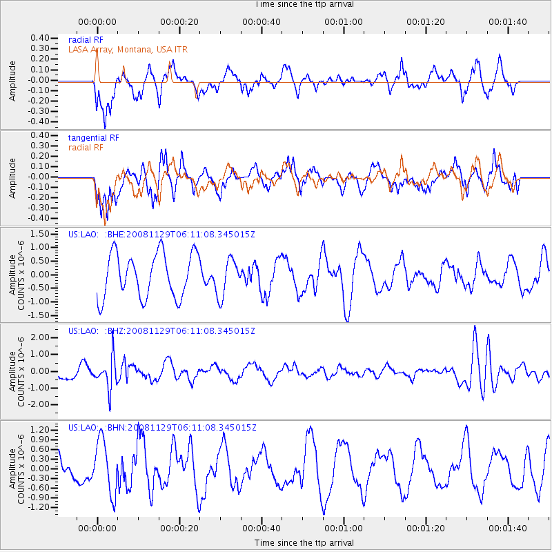
Signal To Noise
| Channel | StoN | STA | LTA |
| US:LAO: :BHZ:20081129T06:11:08.345015Z | 2.1603332 | 9.411387E-7 | 4.3564518E-7 |
| US:LAO: :BHN:20081129T06:11:08.345015Z | 1.5865518 | 8.4677566E-7 | 5.337208E-7 |
| US:LAO: :BHE:20081129T06:11:08.345015Z | 0.8614594 | 6.971488E-7 | 8.092648E-7 |
| Arrivals |
| Ps | |
| PpPs | |
| PsPs/PpSs | |


