You are here: Home > Network List > US - United States National Seismic Network Stations List
> Station LAO LASA Array, Montana, USA > Earthquake Result Viewer
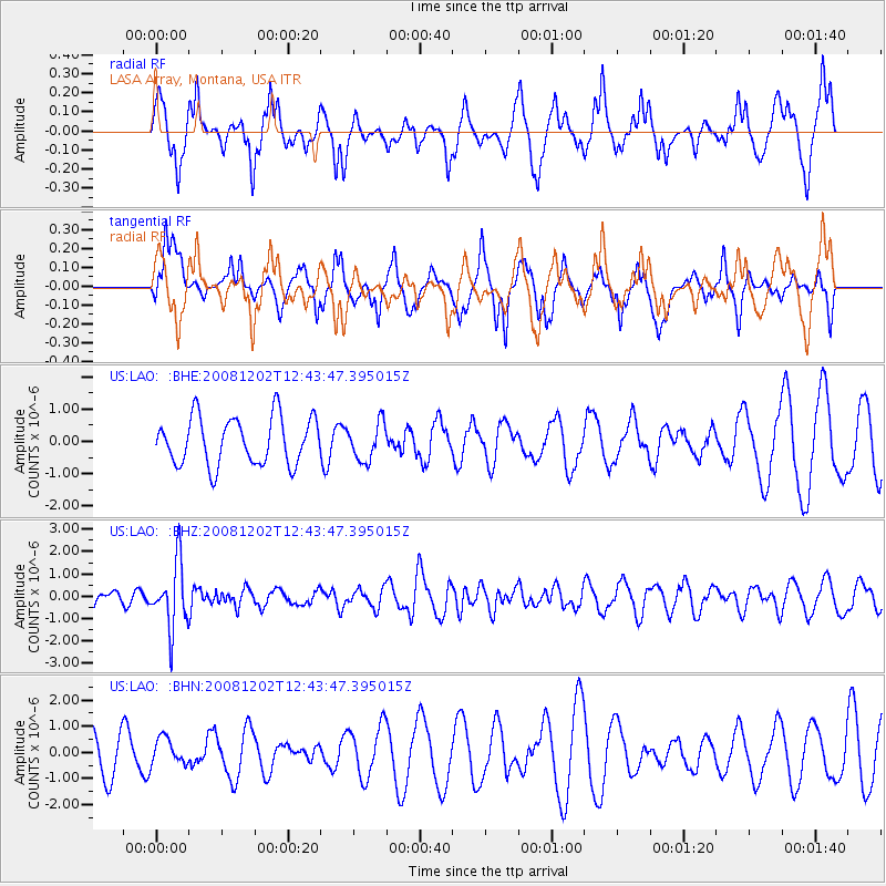
LAO LASA Array, Montana, USA - Earthquake Result Viewer
*The percent match for this event was below the threshold and hence no stack was calculated.
| Earthquake location: |
Mariana Islands |
| Earthquake latitude/longitude: |
19.1/145.8 |
| Earthquake time(UTC): |
2008/12/02 (337) 12:31:43 GMT |
| Earthquake Depth: |
137 km |
| Earthquake Magnitude: |
5.9 MB, 5.9 MW, 5.9 MW |
| Earthquake Catalog/Contributor: |
WHDF/NEIC |
|
| Network: |
US United States National Seismic Network |
| Station: |
LAO LASA Array, Montana, USA |
| Lat/Lon: |
46.69 N/106.22 W |
| Elevation: |
902 m |
|
| Distance: |
88.0 deg |
| Az: |
40.92 deg |
| Baz: |
295.881 deg |
| Ray Param: |
$rayparam |
*The percent match for this event was below the threshold and hence was not used in the summary stack. |
|
| Radial Match: |
76.74241 % |
| Radial Bump: |
370 |
| Transverse Match: |
35.6776 % |
| Transverse Bump: |
289 |
| SOD ConfigId: |
2658 |
| Insert Time: |
2010-03-05 07:13:18.332 +0000 |
| GWidth: |
2.5 |
| Max Bumps: |
400 |
| Tol: |
0.001 |
|
Signal To Noise
| Channel | StoN | STA | LTA |
| US:LAO: :BHZ:20081202T12:43:47.395015Z | 3.6264682 | 1.4545182E-6 | 4.0108392E-7 |
| US:LAO: :BHN:20081202T12:43:47.395015Z | 0.706298 | 5.0803965E-7 | 7.192993E-7 |
| US:LAO: :BHE:20081202T12:43:47.395015Z | 0.78633446 | 5.7450575E-7 | 7.3061244E-7 |
| Arrivals |
| Ps | |
| PpPs | |
| PsPs/PpSs | |


