You are here: Home > Network List > US - United States National Seismic Network Stations List
> Station LAO LASA Array, Montana, USA > Earthquake Result Viewer
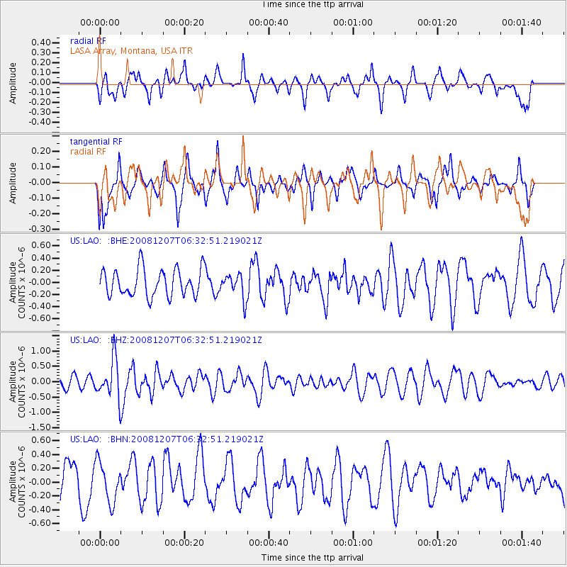
LAO LASA Array, Montana, USA - Earthquake Result Viewer
*The percent match for this event was below the threshold and hence no stack was calculated.
| Earthquake location: |
Northern Mid-Atlantic Ridge |
| Earthquake latitude/longitude: |
13.4/-44.8 |
| Earthquake time(UTC): |
2008/12/07 (342) 06:23:09 GMT |
| Earthquake Depth: |
10 km |
| Earthquake Magnitude: |
5.6 MB, 5.3 MS, 5.7 MW |
| Earthquake Catalog/Contributor: |
WHDF/NEIC |
|
| Network: |
US United States National Seismic Network |
| Station: |
LAO LASA Array, Montana, USA |
| Lat/Lon: |
46.69 N/106.22 W |
| Elevation: |
902 m |
|
| Distance: |
60.8 deg |
| Az: |
316.205 deg |
| Baz: |
101.897 deg |
| Ray Param: |
$rayparam |
*The percent match for this event was below the threshold and hence was not used in the summary stack. |
|
| Radial Match: |
60.321014 % |
| Radial Bump: |
400 |
| Transverse Match: |
47.93714 % |
| Transverse Bump: |
400 |
| SOD ConfigId: |
2658 |
| Insert Time: |
2010-03-05 07:13:19.651 +0000 |
| GWidth: |
2.5 |
| Max Bumps: |
400 |
| Tol: |
0.001 |
|
Signal To Noise
| Channel | StoN | STA | LTA |
| US:LAO: :BHZ:20081207T06:32:51.219021Z | 5.183281 | 6.5421085E-7 | 1.2621558E-7 |
| US:LAO: :BHN:20081207T06:32:51.219021Z | 1.0059807 | 2.9200928E-7 | 2.9027322E-7 |
| US:LAO: :BHE:20081207T06:32:51.219021Z | 0.91863763 | 2.0535492E-7 | 2.235429E-7 |
| Arrivals |
| Ps | |
| PpPs | |
| PsPs/PpSs | |


