You are here: Home > Network List > TA - USArray Transportable Network (new EarthScope stations) Stations List
> Station J26L Joseph Creek, AK, USA > Earthquake Result Viewer
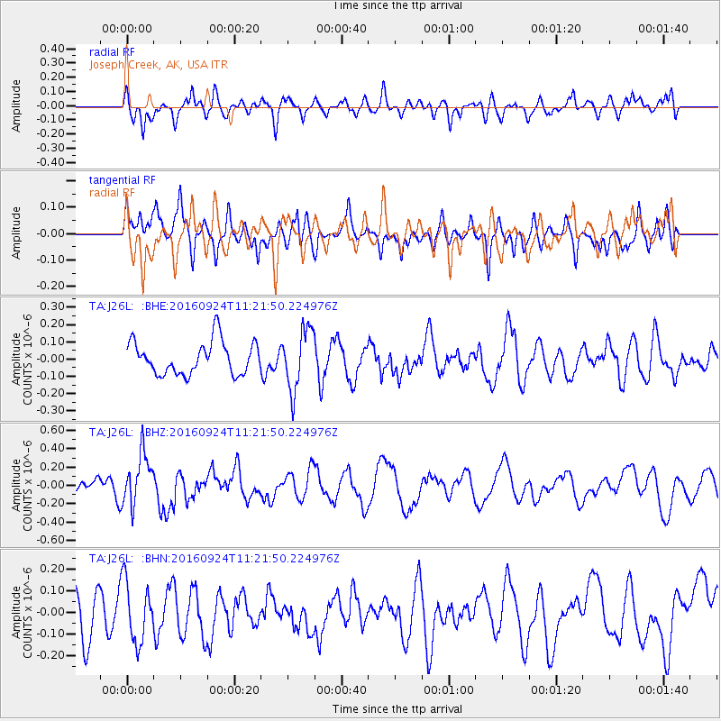
J26L Joseph Creek, AK, USA - Earthquake Result Viewer
*The percent match for this event was below the threshold and hence no stack was calculated.
| Earthquake location: |
Irian Jaya Region, Indonesia |
| Earthquake latitude/longitude: |
-1.9/140.6 |
| Earthquake time(UTC): |
2016/09/24 (268) 11:09:44 GMT |
| Earthquake Depth: |
14 km |
| Earthquake Magnitude: |
5.6 MB |
| Earthquake Catalog/Contributor: |
NEIC PDE/NEIC ALERT |
|
| Network: |
TA USArray Transportable Network (new EarthScope stations) |
| Station: |
J26L Joseph Creek, AK, USA |
| Lat/Lon: |
64.50 N/143.56 W |
| Elevation: |
1144 m |
|
| Distance: |
85.6 deg |
| Az: |
24.896 deg |
| Baz: |
256.421 deg |
| Ray Param: |
$rayparam |
*The percent match for this event was below the threshold and hence was not used in the summary stack. |
|
| Radial Match: |
59.16637 % |
| Radial Bump: |
400 |
| Transverse Match: |
44.2656 % |
| Transverse Bump: |
400 |
| SOD ConfigId: |
11737051 |
| Insert Time: |
2019-04-25 14:49:26.264 +0000 |
| GWidth: |
2.5 |
| Max Bumps: |
400 |
| Tol: |
0.001 |
|
Signal To Noise
| Channel | StoN | STA | LTA |
| TA:J26L: :BHZ:20160924T11:21:50.224976Z | 2.8421254 | 2.7735786E-7 | 9.7588185E-8 |
| TA:J26L: :BHN:20160924T11:21:50.224976Z | 1.2485911 | 1.3695507E-7 | 1.0968769E-7 |
| TA:J26L: :BHE:20160924T11:21:50.224976Z | 1.8705757 | 1.7752421E-7 | 9.490352E-8 |
| Arrivals |
| Ps | |
| PpPs | |
| PsPs/PpSs | |


