You are here: Home > Network List > IW - Intermountain West Stations List
> Station MOOW Moose Ponds, Wyoming, USA > Earthquake Result Viewer
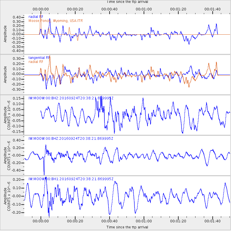
MOOW Moose Ponds, Wyoming, USA - Earthquake Result Viewer
*The percent match for this event was below the threshold and hence no stack was calculated.
| Earthquake location: |
Chile-Bolivia Border Region |
| Earthquake latitude/longitude: |
-21.5/-68.4 |
| Earthquake time(UTC): |
2016/09/24 (268) 20:27:18 GMT |
| Earthquake Depth: |
104 km |
| Earthquake Magnitude: |
5.1 Mww |
| Earthquake Catalog/Contributor: |
NEIC PDE/us |
|
| Network: |
IW Intermountain West |
| Station: |
MOOW Moose Ponds, Wyoming, USA |
| Lat/Lon: |
43.75 N/110.74 W |
| Elevation: |
2128 m |
|
| Distance: |
75.7 deg |
| Az: |
329.723 deg |
| Baz: |
139.63 deg |
| Ray Param: |
$rayparam |
*The percent match for this event was below the threshold and hence was not used in the summary stack. |
|
| Radial Match: |
64.33872 % |
| Radial Bump: |
400 |
| Transverse Match: |
54.678185 % |
| Transverse Bump: |
400 |
| SOD ConfigId: |
11737051 |
| Insert Time: |
2019-04-25 14:55:42.950 +0000 |
| GWidth: |
2.5 |
| Max Bumps: |
400 |
| Tol: |
0.001 |
|
Signal To Noise
| Channel | StoN | STA | LTA |
| IW:MOOW:00:BHZ:20160924T20:38:21.869995Z | 2.7619696 | 1.5318021E-7 | 5.54605E-8 |
| IW:MOOW:00:BH1:20160924T20:38:21.869995Z | 2.1773403 | 1.3070563E-7 | 6.0029954E-8 |
| IW:MOOW:00:BH2:20160924T20:38:21.869995Z | 1.4459112 | 7.305119E-8 | 5.05226E-8 |
| Arrivals |
| Ps | |
| PpPs | |
| PsPs/PpSs | |


