You are here: Home > Network List > US - United States National Seismic Network Stations List
> Station AMTX Amarillo, Texas, USA > Earthquake Result Viewer
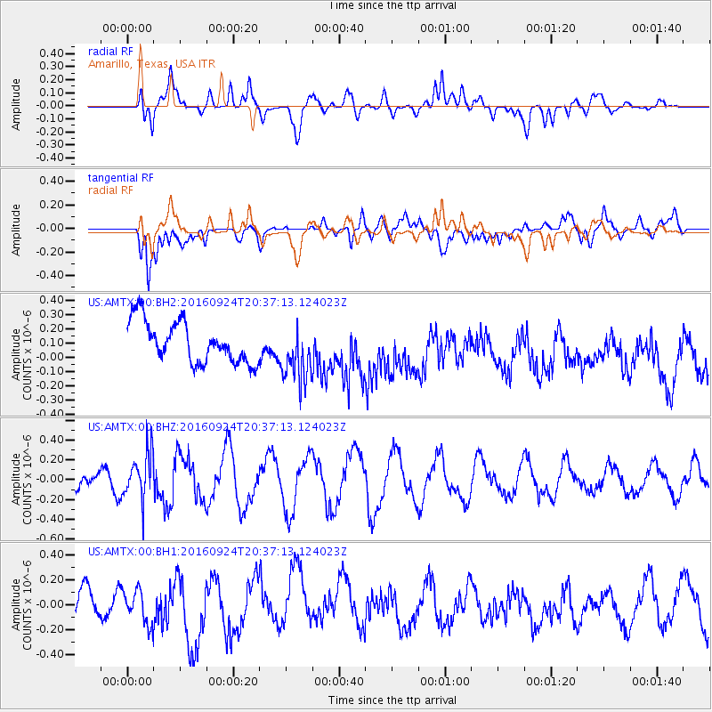
AMTX Amarillo, Texas, USA - Earthquake Result Viewer
*The percent match for this event was below the threshold and hence no stack was calculated.
| Earthquake location: |
Chile-Bolivia Border Region |
| Earthquake latitude/longitude: |
-21.5/-68.4 |
| Earthquake time(UTC): |
2016/09/24 (268) 20:27:18 GMT |
| Earthquake Depth: |
104 km |
| Earthquake Magnitude: |
5.1 Mww |
| Earthquake Catalog/Contributor: |
NEIC PDE/us |
|
| Network: |
US United States National Seismic Network |
| Station: |
AMTX Amarillo, Texas, USA |
| Lat/Lon: |
34.53 N/101.41 W |
| Elevation: |
1010 m |
|
| Distance: |
64.0 deg |
| Az: |
329.934 deg |
| Baz: |
145.599 deg |
| Ray Param: |
$rayparam |
*The percent match for this event was below the threshold and hence was not used in the summary stack. |
|
| Radial Match: |
61.91997 % |
| Radial Bump: |
400 |
| Transverse Match: |
64.346634 % |
| Transverse Bump: |
400 |
| SOD ConfigId: |
11737051 |
| Insert Time: |
2019-04-25 15:00:38.723 +0000 |
| GWidth: |
2.5 |
| Max Bumps: |
400 |
| Tol: |
0.001 |
|
Signal To Noise
| Channel | StoN | STA | LTA |
| US:AMTX:00:BHZ:20160924T20:37:13.124023Z | 2.7945638 | 2.3578885E-7 | 8.4374115E-8 |
| US:AMTX:00:BH1:20160924T20:37:13.124023Z | 1.0614446 | 1.323218E-7 | 1.2466198E-7 |
| US:AMTX:00:BH2:20160924T20:37:13.124023Z | 1.1326227 | 1.580773E-7 | 1.3956748E-7 |
| Arrivals |
| Ps | |
| PpPs | |
| PsPs/PpSs | |


